Ichinohe geodata
Ichinohe (Iwate) is a populated place; located in Japan in Asia/Tokyo (GMT+9) time zone. With population of 15,825 people, there are 737 cities with bigger population in this country. Compared to other cities in Japan, 93.7% of cities are located further ↓South; 94.8% of cities are located further ←West and 91% of cities have lower elevation than Ichinohe. Note1


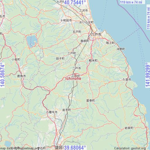
Ichinohe GPS coordinates[2]
40° 13' 10.74" North, 141° 17' 23.496" East
| Map corner | latitude | longitude |
|---|---|---|
| Upper-left | 40.75441°, | 140.58674° |
| Center: | 40.21965°, | 141.28986° |
| Lower-right: | 39.68064°, | 141.99299° |
| Map W x H: | 119.4×119.4 km | = 74.2×74.2mi |
| max Lat: | 45.40944° ⇑6.3% North |
| Ichinohe: | 40.21965° |
| min Lat: | ⇓93.7% South 24.34478° |
| min Long | Ichinohe | max Long |
| 123° | 141.28986° | 145.575° |
| W 94.8%⇐ | ⇒5.2% E |
Elevation
Elevation of Ichinohe is 243 m = 797 ft, and this is 158.4 m = 520 ft above average elevation for this country.
| Max E: |
1086 m = 3563 ft | 9% |
| Ichinohe | 243 m 797 ft | |
| Avg. | 84.6 m = 278 ft | |
Min E: |
-2 m = -7 ft | 91% |
See also: Japan elevation on elevation.city.
Geographical zone
Ichinohe is located in North temperate zone (between Tropic of Cancer and the Arctic Circle). Distance of this Northern Tropic circle is 1866.1 km =1159.5 mi to South.| Distance of | km | miles | from Ichinohe |
|---|---|---|---|
| North Pole | 5535.1 | 3439.4 | to North |
| Arctic Circle | 2929.2 | 1820.1 | to North |
| Tropic Cancer | 1866.1 | 1159.5 | to South |
| Equator | 4472 | 2778.8 | to South |


Nearby cities:
15 places around Ichinohe: (largest is in red/bold)
• Furudate
34.5 km =21.4 mi,  2°
2°
• Hachimantai
38.1 km =23.7 mi,  200°
200°
• Hachinohe
35.9 km =22.3 mi,  29°
29°
• Hanawa
42.9 km =26.7 mi,  264°
264°
• Inuotose
42.6 km =26.5 mi, 4°
• Kazuno
43 km =26.7 mi,  268°
268°
• Kuji
40.8 km =25.4 mi,  94°
94°
• Kuroishi
66.3 km =41.2 mi,  311°
311°
• Misawa
52.6 km =32.7 mi,  9°
9°
• Morioka
59 km =36.7 mi,  191°
191°
• Ninohe
8.2 km =5.1 mi, 14°
• Shizukuishi
64 km =39.8 mi, 204°
• Takizawa
48.2 km =30 mi, 195°
• Towada
45.1 km =28 mi,  351°
351°
• Ōdate
62.4 km =38.8 mi,  275°
275°
Sources, notices
• [Note1] Compared only with cities in Japan existing in our database
• [Src1] Map data: © OpenStreetMap contributors (CC-BY-SA)
• [Src2] Other city data from geonames.org with taken over terms of usage.
• [Src3] Geographical zone / Annual Mean Temperature by Robert A. Rohde @ Wikipedia
