Aomori geodata
Aomori is a seat of a first-order administrative division; located in Japan in Asia/Tokyo (GMT+9) time zone. With population of 298,394 people, there are 65 cities with bigger population in this country. Compared to other cities in Japan, 95.2% of cities are located further ↓South; 90.3% of cities are located further ←West and 81.8% of cities have higher elevation than Aomori. Note1


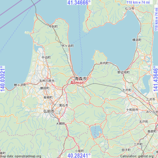
Aomori GPS coordinates[2]
40° 49' 0.012" North, 140° 43' 59.988" East
| Map corner | latitude | longitude |
|---|---|---|
| Upper-left | 41.34666°, | 140.03021° |
| Center: | 40.81667°, | 140.73333° |
| Lower-right: | 40.28241°, | 141.43646° |
| Map W x H: | 118.3×118.3 km | = 73.5×73.5mi |
| max Lat: | 45.40944° ⇑4.8% North |
| Aomori: | 40.81667° |
| min Lat: | ⇓95.2% South 24.34478° |
| min Long | Aomori | max Long |
| 123° | 140.73333° | 145.575° |
| W 90.3%⇐ | ⇒9.7% E |
Elevation
Elevation of Aomori is 7 m = 23 ft, and this is 77.6 m = 255 ft below average elevation for this country.
| Max E: |
1086 m = 3563 ft | 81.8% |
| Avg. | 84.6 m = 278 ft | |
| Aomori | 7 m = 23 ft | |
Min E: |
-2 m = -7 ft | 18.2% |
See also: Aomori elevation on elevation.city.
Geographical zone
Aomori is located in North temperate zone (between Tropic of Cancer and the Arctic Circle). Distance of this Northern Tropic circle is 1932.5 km =1200.8 mi to South.| Distance of | km | miles | from Aomori |
|---|---|---|---|
| North Pole | 5468.7 | 3398.1 | to North |
| Arctic Circle | 2862.8 | 1778.9 | to North |
| Tropic Cancer | 1932.5 | 1200.8 | to South |
| Equator | 4538.4 | 2820 | to South |


Nearby cities:
15 places around Aomori: (largest is in red/bold)
• Furudate
57.9 km =36 mi,  123°
123°
• Goshogawara
24.6 km =15.3 mi,  266°
266°
• Hirakawa
28.9 km =18 mi,  208°
208°
• Hirosaki
33.2 km =20.6 mi,  221°
221°
• Inuotose
55.4 km =34.4 mi, 115°
• Kazuno
67.8 km =42.1 mi,  176°
176°
• Kuroishi
22.5 km =14 mi,  186°
186°
• Kuroishi
22.8 km =14.2 mi, 213°
• Misawa
57.1 km =35.5 mi,  104°
104°
• Mutsu
66.4 km =41.3 mi,  37°
37°
• Namioka
16.8 km =10.4 mi,  225°
225°
• Shimokizukuri
30.1 km =18.7 mi, 269°
• Towada
45.8 km =28.5 mi, 118°
• Tsugaru
27.8 km =17.3 mi, 267°
• Ōdate
62.4 km =38.8 mi, 193°
Sources, notices
• [Note1] Compared only with cities in Japan existing in our database
• [Src1] Map data: © OpenStreetMap contributors (CC-BY-SA)
• [Src2] Other city data from geonames.org with taken over terms of usage.
• [Src3] Geographical zone / Annual Mean Temperature by Robert A. Rohde @ Wikipedia
