Inuotose geodata
Inuotose (Aomori) is a seat of a third-order administrative division; located in Japan in Asia/Tokyo (GMT+9) time zone. In our database, there are 767 cities with bigger population. Compared to other cities in Japan, 94.4% of cities are located further ↓South; 95.1% of cities are located further ←West and 63.7% of cities have higher elevation than Inuotose. Note1


Inuotose GPS coordinates[2]
40° 36' 6.336" North, 141° 19' 35.832" East
| Map corner | latitude | longitude |
|---|---|---|
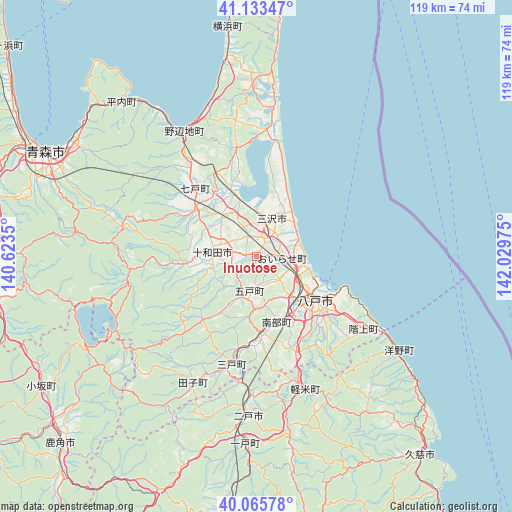
| Upper-left | 41.13347°, | 140.6235° |
| Center: | 40.60176°, | 141.32662° |
| Lower-right: | 40.06578°, | 142.02975° |
| Map W x H: | 118.7×118.7 km | = 73.8×73.8mi |
| max Lat: | 45.40944° ⇑5.6% North |
| Inuotose: | 40.60176° |
| min Lat: | ⇓94.4% South 24.34478° |
| min Long | Inuotose | max Long |
| 123° | 141.32662° | 145.575° |
| W 95.1%⇐ | ⇒4.9% E |
Elevation
Elevation of Inuotose is 16 m = 52 ft, and this is 68.6 m = 225 ft below average elevation for this country.
| Max E: |
1086 m = 3563 ft | 63.7% |
| Avg. | 84.6 m = 278 ft | |
| Inuotose | 16 m = 52 ft | |
Min E: |
-2 m = -7 ft | 36.3% |
See also: Japan elevation on elevation.city.
Geographical zone
Inuotose is located in North temperate zone (between Tropic of Cancer and the Arctic Circle). Distance of this Northern Tropic circle is 1908.6 km =1185.9 mi to South.| Distance of | km | miles | from Inuotose |
|---|---|---|---|
| North Pole | 5492.6 | 3412.9 | to North |
| Arctic Circle | 2886.7 | 1793.7 | to North |
| Tropic Cancer | 1908.6 | 1185.9 | to South |
| Equator | 4514.5 | 2805.2 | to South |


Nearby cities:
15 places around Inuotose: (largest is in red/bold)
• Aomori
55.4 km =34.4 mi,  295°
295°
• Furudate
8.2 km =5.1 mi,  192°
192°
• Hachinohe
18.5 km =11.5 mi,  127°
127°
• Hanawa
65.2 km =40.5 mi,  224°
224°
• Hirakawa
63.8 km =39.6 mi,  268°
268°
• Hirosaki
72.1 km =44.8 mi, 269°
• Ichinohe
42.6 km =26.5 mi,  184°
184°
• Kazuno
63.5 km =39.5 mi,  226°
226°
• Kuji
59.3 km =36.8 mi,  140°
140°
• Kuroishi
52.6 km =32.7 mi, 271°
• Kuroishi
62.9 km =39.1 mi, 274°
• Misawa
10.9 km =6.8 mi,  29°
29°
• Namioka
63.3 km =39.3 mi,  281°
281°
• Ninohe
34.6 km =21.5 mi, 181°
• Towada
10 km =6.2 mi, 282°
Sources, notices
• [Note1] Compared only with cities in Japan existing in our database
• [Src1] Map data: © OpenStreetMap contributors (CC-BY-SA)
• [Src2] Other city data from geonames.org with taken over terms of usage.
• [Src3] Geographical zone / Annual Mean Temperature by Robert A. Rohde @ Wikipedia
