Towada geodata
Towada (Aomori) is a seat of a second-order administrative division; located in Japan in Asia/Tokyo (GMT+9) time zone. In our database, there are 767 cities with bigger population. Compared to other cities in Japan, 94.6% of cities are located further ↓South; 94.5% of cities are located further ←West and 70.6% of cities have lower elevation than Towada. Note1


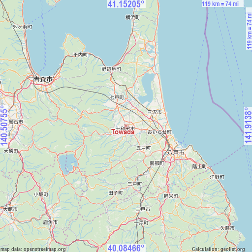
Towada GPS coordinates[2]
40° 37' 13.764" North, 141° 12' 38.412" East
| Map corner | latitude | longitude |
|---|---|---|
| Upper-left | 41.15205°, | 140.50755° |
| Center: | 40.62049°, | 141.21067° |
| Lower-right: | 40.08466°, | 141.9138° |
| Map W x H: | 118.7×118.7 km | = 73.8×73.8mi |
| max Lat: | 45.40944° ⇑5.4% North |
| Towada: | 40.62049° |
| min Lat: | ⇓94.6% South 24.34478° |
| min Long | Towada | max Long |
| 123° | 141.21067° | 145.575° |
| W 94.5%⇐ | ⇒5.5% E |
Elevation
Elevation of Towada is 74 m = 243 ft, and this is 10.6 m = 35 ft below average elevation for this country.
| Max E: |
1086 m = 3563 ft | 29.4% |
| Avg. | 84.6 m = 278 ft | |
| Towada | 74 m = 243 ft | |
Min E: |
-2 m = -7 ft | 70.6% |
See also: Japan elevation on elevation.city.
Geographical zone
Towada is located in North temperate zone (between Tropic of Cancer and the Arctic Circle). Distance of this Northern Tropic circle is 1910.7 km =1187.3 mi to South.| Distance of | km | miles | from Towada |
|---|---|---|---|
| North Pole | 5490.5 | 3411.6 | to North |
| Arctic Circle | 2884.6 | 1792.4 | to North |
| Tropic Cancer | 1910.7 | 1187.3 | to South |
| Equator | 4516.6 | 2806.5 | to South |


Nearby cities:
15 places around Towada: (largest is in red/bold)
• Aomori
45.8 km =28.5 mi,  298°
298°
• Furudate
12.9 km =8 mi,  141°
141°
• Hachinohe
27.9 km =17.3 mi,  118°
118°
• Hanawa
60.4 km =37.5 mi,  216°
216°
• Hirakawa
54.1 km =33.6 mi,  266°
266°
• Hirosaki
62.4 km =38.8 mi, 267°
• Ichinohe
45.1 km =28 mi,  171°
171°
• Inuotose
10 km =6.2 mi,  102°
102°
• Kazuno
58.4 km =36.3 mi, 218°
• Kuji
67.4 km =41.9 mi, 135°
• Kuroishi
42.8 km =26.6 mi, 269°
• Kuroishi
53 km =32.9 mi, 273°
• Misawa
16.8 km =10.4 mi,  63°
63°
• Namioka
53.3 km =33.1 mi,  280°
280°
• Ninohe
37.7 km =23.4 mi, 166°
Sources, notices
• [Note1] Compared only with cities in Japan existing in our database
• [Src1] Map data: © OpenStreetMap contributors (CC-BY-SA)
• [Src2] Other city data from geonames.org with taken over terms of usage.
• [Src3] Geographical zone / Annual Mean Temperature by Robert A. Rohde @ Wikipedia
