Mutsu geodata
Mutsu (Aomori) is a seat of a second-order administrative division; located in Japan in Asia/Tokyo (GMT+9) time zone. With population of 49,220 people, there are 380 cities with bigger population in this country. Compared to other cities in Japan, 95.3% of cities are located further ↓South; 94.7% of cities are located further ←West and 86% of cities have higher elevation than Mutsu. Note1


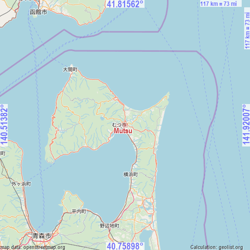
Mutsu GPS coordinates[2]
41° 17' 21.984" North, 141° 13' 0.984" East
| Map corner | latitude | longitude |
|---|---|---|
| Upper-left | 41.81562°, | 140.51382° |
| Center: | 41.28944°, | 141.21694° |
| Lower-right: | 40.75898°, | 141.92007° |
| Map W x H: | 117.5×117.5 km | = 73×73mi |
| max Lat: | 45.40944° ⇑4.7% North |
| Mutsu: | 41.28944° |
| min Lat: | ⇓95.3% South 24.34478° |
| min Long | Mutsu | max Long |
| 123° | 141.21694° | 145.575° |
| W 94.7%⇐ | ⇒5.3% E |
Elevation
Elevation of Mutsu is 6 m = 20 ft, and this is 78.6 m = 258 ft below average elevation for this country.
| Max E: |
1086 m = 3563 ft | 86% |
| Avg. | 84.6 m = 278 ft | |
| Mutsu | 6 m = 20 ft | |
Min E: |
-2 m = -7 ft | 14% |
See also: Mutsu elevation on elevation.city.
Geographical zone
Mutsu is located in North temperate zone (between Tropic of Cancer and the Arctic Circle). Distance of this Northern Tropic circle is 1985 km =1233.4 mi to South.| Distance of | km | miles | from Mutsu |
|---|---|---|---|
| North Pole | 5416.1 | 3365.4 | to North |
| Arctic Circle | 2810.2 | 1746.2 | to North |
| Tropic Cancer | 1985 | 1233.4 | to South |
| Equator | 4591 | 2852.7 | to South |


Nearby cities:
15 places around Mutsu: (largest is in red/bold)
• Aomori
66.4 km =41.3 mi,  217°
217°
• Furudate
84.8 km =52.7 mi,  174°
174°
• Goshogawara
84.5 km =52.5 mi,  230°
230°
• Hakodate
67.3 km =41.8 mi,  323°
323°
• Hokuto
76 km =47.2 mi, 320°
• Honchō
80.1 km =49.8 mi,  327°
327°
• Inuotose
77 km =47.8 mi, 173°
• Kamiiso
75.8 km =47.1 mi, 321°
• Kuroishi
86.5 km =53.7 mi,  209°
209°
• Kuroishi
89.2 km =55.4 mi, 216°
• Misawa
68.6 km =42.6 mi, 167°
• Namioka
83.1 km =51.6 mi, 219°
• Shimokizukuri
88 km =54.7 mi, 233°
• Towada
74.4 km =46.2 mi,  180°
180°
• Tsugaru
87 km =54.1 mi, 231°
Sources, notices
• [Note1] Compared only with cities in Japan existing in our database
• [Src1] Map data: © OpenStreetMap contributors (CC-BY-SA)
• [Src2] Other city data from geonames.org with taken over terms of usage.
• [Src3] Geographical zone / Annual Mean Temperature by Robert A. Rohde @ Wikipedia
