Akune geodata
Akune (Kagoshima) is a seat of a second-order administrative division; located in Japan in Asia/Tokyo (GMT+9) time zone. With population of 25,089 people, there are 612 cities with bigger population in this country. Compared to other cities in Japan, 95% of cities are located further ↑North; 95.8% of cities are located further →East and 86% of cities have higher elevation than Akune. Note1


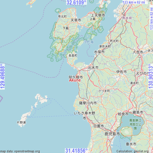
Akune GPS coordinates[2]
32° 1' 0.012" North, 130° 12' 0" East
| Map corner | latitude | longitude |
|---|---|---|
| Upper-left | 32.6109°, | 129.49688° |
| Center: | 32.01667°, | 130.2° |
| Lower-right: | 31.41856°, | 130.90313° |
| Map W x H: | 132.6×132.6 km | = 82.4×82.4mi |
| max Lat: | 45.40944° ⇑95% North |
| Akune: | 32.01667° |
| min Lat: | ⇓5% South 24.34478° |
| min Long | Akune | max Long |
| 123° | 130.2° | 145.575° |
| W 4.2%⇐ | ⇒95.8% E |
Elevation
Elevation of Akune is 6 m = 20 ft, and this is 78.6 m = 258 ft below average elevation for this country.
| Max E: |
1086 m = 3563 ft | 86% |
| Avg. | 84.6 m = 278 ft | |
| Akune | 6 m = 20 ft | |
Min E: |
-2 m = -7 ft | 14% |
See also: Japan elevation on elevation.city.
Geographical zone
Akune is located in North temperate zone (between Tropic of Cancer and the Arctic Circle). Distance of this Northern Tropic circle is 954 km =592.8 mi to South.| Distance of | km | miles | from Akune |
|---|---|---|---|
| North Pole | 6447.1 | 4006 | to North |
| Arctic Circle | 3841.3 | 2386.9 | to North |
| Tropic Cancer | 954 | 592.8 | to South |
| Equator | 3559.9 | 2212 | to South |


Nearby cities:
15 places around Akune: (largest is in red/bold)
• Aira
45.8 km =28.5 mi,  126°
126°
• Amakusa
49.1 km =30.5 mi,  359°
359°
• Hioki
50.2 km =31.2 mi,  163°
163°
• Hondomachi-hondo
49.4 km =30.7 mi, 356°
• Ichikikushikino
33.1 km =20.6 mi, 164°
• Ijūin
48.3 km =30 mi, 156°
• Isa
39.2 km =24.4 mi,  81°
81°
• Izumi
17.4 km =10.8 mi,  64°
64°
• Kajiki
54.2 km =33.7 mi, 125°
• Kushikino
33.9 km =21.1 mi,  169°
169°
• Minamata
29.1 km =18.1 mi,  40°
40°
• Satsumasendai
24.2 km =15 mi, 157°
• Ushibukamachi
26.5 km =16.5 mi,  320°
320°
• Yotsueda
50.5 km =31.4 mi,  90°
90°
• Ōkuchi-shinohara
40.4 km =25.1 mi, 81°
Sources, notices
• [Note1] Compared only with cities in Japan existing in our database
• [Src1] Map data: © OpenStreetMap contributors (CC-BY-SA)
• [Src2] Other city data from geonames.org with taken over terms of usage.
• [Src3] Geographical zone / Annual Mean Temperature by Robert A. Rohde @ Wikipedia
