Izumi geodata
Izumi (Kagoshima) is a seat of a second-order administrative division; located in Japan in Asia/Tokyo (GMT+9) time zone. With population of 39,217 people, there are 462 cities with bigger population in this country. Compared to other cities in Japan, 94.5% of cities are located further ↑North; 94.6% of cities are located further →East and 56.3% of cities have lower elevation than Izumi. Note1


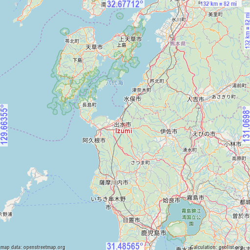
Izumi GPS coordinates[2]
32° 4' 59.988" North, 130° 22' 0.012" East
| Map corner | latitude | longitude |
|---|---|---|
| Upper-left | 32.67712°, | 129.66355° |
| Center: | 32.08333°, | 130.36667° |
| Lower-right: | 31.48565°, | 131.0698° |
| Map W x H: | 132.5×132.5 km | = 82.3×82.3mi |
| max Lat: | 45.40944° ⇑94.5% North |
| Izumi: | 32.08333° |
| min Lat: | ⇓5.5% South 24.34478° |
| min Long | Izumi | max Long |
| 123° | 130.36667° | 145.575° |
| W 5.4%⇐ | ⇒94.6% E |
Elevation
Elevation of Izumi is 37 m = 121 ft, and this is 47.6 m = 156 ft below average elevation for this country.
| Max E: |
1086 m = 3563 ft | 43.7% |
| Avg. | 84.6 m = 278 ft | |
| Izumi | 37 m = 121 ft | |
Min E: |
-2 m = -7 ft | 56.3% |
See also: Japan elevation on elevation.city.
Geographical zone
Izumi is located in North temperate zone (between Tropic of Cancer and the Arctic Circle). Distance of this Northern Tropic circle is 961.4 km =597.4 mi to South.| Distance of | km | miles | from Izumi |
|---|---|---|---|
| North Pole | 6439.7 | 4001.4 | to North |
| Arctic Circle | 3833.8 | 2382.2 | to North |
| Tropic Cancer | 961.4 | 597.4 | to South |
| Equator | 3567.3 | 2216.6 | to South |


Nearby cities:
15 places around Izumi: (largest is in red/bold)
• Aira
40.4 km =25.1 mi,  148°
148°
• Akune
17.4 km =10.8 mi,  244°
244°
• Amakusa
44.8 km =27.8 mi,  338°
338°
• Ebino
45.2 km =28.1 mi,  95°
95°
• Hitoyoshi
39 km =24.2 mi,  67°
67°
• Hondomachi-hondo
45.9 km =28.5 mi, 335°
• Ichikikushikino
40 km =24.9 mi,  190°
190°
• Isa
23.2 km =14.4 mi,  94°
94°
• Kamiamakusa
45.2 km =28.1 mi,  3°
3°
• Kushikino
41.8 km =26 mi, 193°
• Minamata
15.2 km =9.4 mi,  11°
11°
• Satsumasendai
30.3 km =18.8 mi, 191°
• Ushibukamachi
35 km =21.7 mi,  292°
292°
• Yotsueda
35.6 km =22.1 mi, 102°
• Ōkuchi-shinohara
24.3 km =15.1 mi, 94°
Sources, notices
• [Note1] Compared only with cities in Japan existing in our database
• [Src1] Map data: © OpenStreetMap contributors (CC-BY-SA)
• [Src2] Other city data from geonames.org with taken over terms of usage.
• [Src3] Geographical zone / Annual Mean Temperature by Robert A. Rohde @ Wikipedia
