Tonoshō geodata
Tonoshō (Kagawa) is a populated place; located in Japan in Asia/Tokyo (GMT+9) time zone. With population of 16,514 people, there are 730 cities with bigger population in this country. Compared to other cities in Japan, 73.2% of cities are located further ↑North; 74.3% of cities are located further →East and 61.6% of cities have lower elevation than Tonoshō. Note1


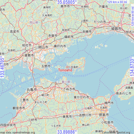
Tonoshō GPS coordinates[2]
34° 28' 49.692" North, 134° 10' 12.612" East
| Map corner | latitude | longitude |
|---|---|---|
| Upper-left | 35.05805°, | 133.46705° |
| Center: | 34.48047°, | 134.17017° |
| Lower-right: | 33.89886°, | 134.8733° |
| Map W x H: | 128.9×128.9 km | = 80.1×80.1mi |
| max Lat: | 45.40944° ⇑73.2% North |
| Tonoshō: | 34.48047° |
| min Lat: | ⇓26.8% South 24.34478° |
| min Long | Tonoshō | max Long |
| 123° | 134.17017° | 145.575° |
| W 25.7%⇐ | ⇒74.3% E |
Elevation
Elevation of Tonoshō is 49 m = 161 ft, and this is 35.6 m = 117 ft below average elevation for this country.
| Max E: |
1086 m = 3563 ft | 38.4% |
| Avg. | 84.6 m = 278 ft | |
| Tonoshō | 49 m = 161 ft | |
Min E: |
-2 m = -7 ft | 61.6% |
See also: Japan elevation on elevation.city.
Geographical zone
Tonoshō is located in North temperate zone (between Tropic of Cancer and the Arctic Circle). Distance of this Northern Tropic circle is 1227.9 km =763 mi to South.| Distance of | km | miles | from Tonoshō |
|---|---|---|---|
| North Pole | 6173.2 | 3835.8 | to North |
| Arctic Circle | 3567.3 | 2216.6 | to North |
| Tropic Cancer | 1227.9 | 763 | to South |
| Equator | 3833.9 | 2382.3 | to South |


Nearby cities:
15 places around Tonoshō: (largest is in red/bold)
• Akaiwa
39.1 km =24.3 mi,  339°
339°
• Ako
36 km =22.4 mi,  30°
30°
• Bizen
34.6 km =21.5 mi,  9°
9°
• Higashikagawa
33.7 km =20.9 mi,  153°
153°
• Kariya
36.1 km =22.4 mi, 33°
• Kurashiki
38.7 km =24 mi,  287°
287°
• Marugame
41.7 km =25.9 mi,  238°
238°
• Okayama
28.7 km =17.8 mi,  310°
310°
• Sakaidechō
35.3 km =21.9 mi, 240°
• Sanuki
24.4 km =15.2 mi,  167°
167°
• Setouchi
20 km =12.4 mi,  352°
352°
• Shido
17.5 km =10.9 mi,  179°
179°
• Sōja
44.1 km =27.4 mi,  299°
299°
• Takamatsu
19.7 km =12.2 mi,  213°
213°
• Tamano
21 km =13 mi,  281°
281°
Sources, notices
• [Note1] Compared only with cities in Japan existing in our database
• [Src1] Map data: © OpenStreetMap contributors (CC-BY-SA)
• [Src2] Other city data from geonames.org with taken over terms of usage.
• [Src3] Geographical zone / Annual Mean Temperature by Robert A. Rohde @ Wikipedia
