Hida geodata
Hida (Gifu) is a seat of a second-order administrative division; located in Japan in Asia/Tokyo (GMT+9) time zone. In our database, there are 767 cities with bigger population. Compared to other cities in Japan, 72.2% of cities are located further ↓South; 50.1% of cities are located further ←West and 96.8% of cities have lower elevation than Hida. Note1


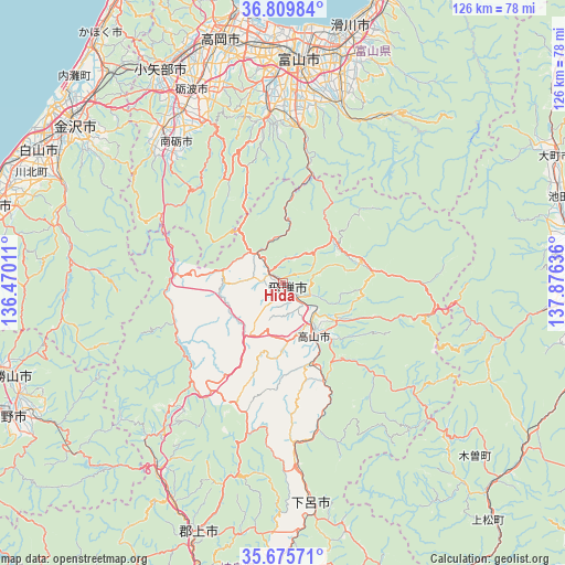
Hida GPS coordinates[2]
36° 14' 41.388" North, 137° 10' 23.628" East
| Map corner | latitude | longitude |
|---|---|---|
| Upper-left | 36.80984°, | 136.47011° |
| Center: | 36.24483°, | 137.17323° |
| Lower-right: | 35.67571°, | 137.87636° |
| Map W x H: | 126.1×126.1 km | = 78.4×78.4mi |
| max Lat: | 45.40944° ⇑27.8% North |
| Hida: | 36.24483° |
| min Lat: | ⇓72.2% South 24.34478° |
| min Long | Hida | max Long |
| 123° | 137.17323° | 145.575° |
| W 50.1%⇐ | ⇒49.9% E |
Elevation
Elevation of Hida is 486 m = 1594 ft, and this is 401.4 m = 1317 ft above average elevation for this country.
| Max E: |
1086 m = 3563 ft | 3.2% |
| Hida | 486 m 1594 ft | |
| Avg. | 84.6 m = 278 ft | |
Min E: |
-2 m = -7 ft | 96.8% |
See also: Japan elevation on elevation.city.
Geographical zone
Hida is located in North temperate zone (between Tropic of Cancer and the Arctic Circle). Distance of this Northern Tropic circle is 1424.1 km =884.9 mi to South.| Distance of | km | miles | from Hida |
|---|---|---|---|
| North Pole | 5977 | 3713.9 | to North |
| Arctic Circle | 3371.1 | 2094.7 | to North |
| Tropic Cancer | 1424.1 | 884.9 | to South |
| Equator | 4030 | 2504.1 | to South |


Nearby cities:
15 places around Hida: (largest is in red/bold)
• Fukumitsu
44.1 km =27.4 mi,  321°
321°
• Gero
49.8 km =30.9 mi,  173°
173°
• Hakusan
58.8 km =36.5 mi,  296°
296°
• Imizu
58.4 km =36.3 mi,  355°
355°
• Kamiichi
53.5 km =33.2 mi,  18°
18°
• Nanto
38.9 km =24.2 mi, 319°
• Nanto-shi
43 km =26.7 mi,  327°
327°
• Nonoichi
59.3 km =36.8 mi, 302°
• Oyabe
55.1 km =34.2 mi, 328°
• Takaoka
57.9 km =36 mi,  346°
346°
• Takayama
14.2 km =8.8 mi,  150°
150°
• Tonami
46.6 km =29 mi, 333°
• Toyama
50.8 km =31.6 mi,  4°
4°
• Tsurugi-asahimachi
53.5 km =33.2 mi, 295°
• Yatsuomachi-higashikumisaka
36 km =22.4 mi, 354°
Sources, notices
• [Note1] Compared only with cities in Japan existing in our database
• [Src1] Map data: © OpenStreetMap contributors (CC-BY-SA)
• [Src2] Other city data from geonames.org with taken over terms of usage.
• [Src3] Geographical zone / Annual Mean Temperature by Robert A. Rohde @ Wikipedia
