Takayama geodata
Takayama (Gifu) is a seat of a second-order administrative division; located in Japan in Asia/Tokyo (GMT+9) time zone. With population of 66,636 people, there are 292 cities with bigger population in this country. Compared to other cities in Japan, 70.2% of cities are located further ↓South; 50.6% of cities are located further ←West and 97.8% of cities have lower elevation than Takayama. Note1


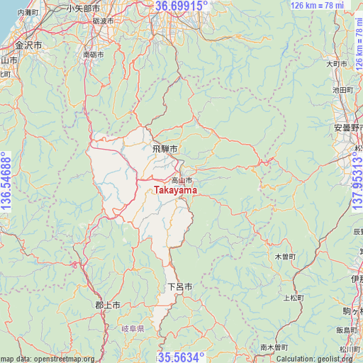
Takayama GPS coordinates[2]
36° 7' 59.988" North, 137° 15' 0" East
| Map corner | latitude | longitude |
|---|---|---|
| Upper-left | 36.69915°, | 136.54688° |
| Center: | 36.13333°, | 137.25° |
| Lower-right: | 35.5634°, | 137.95313° |
| Map W x H: | 126.3×126.3 km | = 78.5×78.5mi |
| max Lat: | 45.40944° ⇑29.8% North |
| Takayama: | 36.13333° |
| min Lat: | ⇓70.2% South 24.34478° |
| min Long | Takayama | max Long |
| 123° | 137.25° | 145.575° |
| W 50.6%⇐ | ⇒49.4% E |
Elevation
Elevation of Takayama is 583 m = 1913 ft, and this is 498.4 m = 1635 ft above average elevation for this country.
| Max E: |
1086 m = 3563 ft | 2.2% |
| Takayama | 583 m 1913 ft | |
| Avg. | 84.6 m = 278 ft | |
Min E: |
-2 m = -7 ft | 97.8% |
See also: Takayama elevation on elevation.city.
Geographical zone
Takayama is located in North temperate zone (between Tropic of Cancer and the Arctic Circle). Distance of this Northern Tropic circle is 1411.7 km =877.2 mi to South.| Distance of | km | miles | from Takayama |
|---|---|---|---|
| North Pole | 5989.4 | 3721.6 | to North |
| Arctic Circle | 3383.5 | 2102.4 | to North |
| Tropic Cancer | 1411.7 | 877.2 | to South |
| Equator | 4017.6 | 2496.4 | to South |


Nearby cities:
15 places around Takayama: (largest is in red/bold)
• Azumino
59.7 km =37.1 mi,  73°
73°
• Fukumitsu
58.2 km =36.2 mi,  324°
324°
• Gero
37.1 km =23.1 mi,  182°
182°
• Gujō
51.3 km =31.9 mi,  210°
210°
• Hida
14.2 km =8.8 mi,  330°
330°
• Hotaka
61.2 km =38 mi, 67°
• Kamiichi
63.9 km =39.7 mi,  9°
9°
• Matsumoto
65.3 km =40.6 mi,  80°
80°
• Nanto
52.9 km =32.9 mi, 322°
• Nanto-shi
57.2 km =35.5 mi, 327°
• Shiojiri
64.5 km =40.1 mi,  93°
93°
• Tonami
60.7 km =37.7 mi, 333°
• Toyama
63.1 km =39.2 mi,  357°
357°
• Toyoshina
61.3 km =38.1 mi, 72°
• Yatsuomachi-higashikumisaka
49.3 km =30.6 mi,  347°
347°
Sources, notices
• [Note1] Compared only with cities in Japan existing in our database
• [Src1] Map data: © OpenStreetMap contributors (CC-BY-SA)
• [Src2] Other city data from geonames.org with taken over terms of usage.
• [Src3] Geographical zone / Annual Mean Temperature by Robert A. Rohde @ Wikipedia
