Shibetsu geodata
Shibetsu (Hokkaido) is a seat of a second-order administrative division; located in Japan in Asia/Tokyo (GMT+9) time zone. In our database, there are 767 cities with bigger population. Compared to other cities in Japan, 99.4% of cities are located further ↓South; 98.9% of cities are located further ←West and 80.9% of cities have lower elevation than Shibetsu. Note1


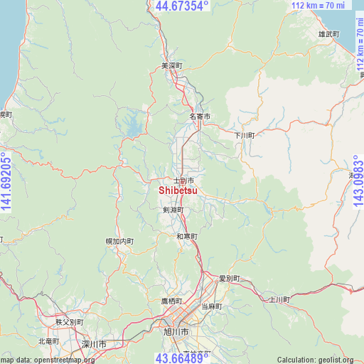
Shibetsu GPS coordinates[2]
44° 10' 16.932" North, 142° 23' 42.612" East
| Map corner | latitude | longitude |
|---|---|---|
| Upper-left | 44.67354°, | 141.69205° |
| Center: | 44.17137°, | 142.39517° |
| Lower-right: | 43.66489°, | 143.0983° |
| Map W x H: | 112.2×112.1 km | = 69.7×69.7mi |
| max Lat: | 45.40944° ⇑0.6% North |
| Shibetsu: | 44.17137° |
| min Lat: | ⇓99.4% South 24.34478° |
| min Long | Shibetsu | max Long |
| 123° | 142.39517° | 145.575° |
| W 98.9%⇐ | ⇒1.1% E |
Elevation
Elevation of Shibetsu is 127 m = 417 ft, and this is 42.4 m = 139 ft above average elevation for this country.
| Max E: |
1086 m = 3563 ft | 19.1% |
| Shibetsu | 127 m 417 ft | |
| Avg. | 84.6 m = 278 ft | |
Min E: |
-2 m = -7 ft | 80.9% |
See also: Japan elevation on elevation.city.
Geographical zone
Shibetsu is located in North temperate zone (between Tropic of Cancer and the Arctic Circle). Distance of this Northern Tropic circle is 2305.5 km =1432.6 mi to South.| Distance of | km | miles | from Shibetsu |
|---|---|---|---|
| North Pole | 5095.7 | 3166.3 | to North |
| Arctic Circle | 2489.8 | 1547.1 | to North |
| Tropic Cancer | 2305.5 | 1432.6 | to South |
| Equator | 4911.4 | 3051.8 | to South |


Nearby cities:
15 places around Shibetsu: (largest is in red/bold)
• Akabira
74.2 km =46.1 mi,  201°
201°
• Asahikawa
44.6 km =27.7 mi,  183°
183°
• Ashibetsu
75.5 km =46.9 mi,  192°
192°
• Bibai
103.5 km =64.3 mi, 204°
• Fukagawa
58.9 km =36.6 mi,  208°
208°
• Furano
91.3 km =56.7 mi, 180°
• Kamikawa
47.6 km =29.6 mi,  140°
140°
• Mobetsu
77.7 km =48.3 mi,  81°
81°
• Mombetsu
78.8 km =49 mi, 75°
• Nayoro
20.5 km =12.7 mi,  14°
14°
• Rumoi
65.6 km =40.8 mi,  246°
246°
• Shimo-furano
91.3 km =56.7 mi, 180°
• Sunagawa
85.7 km =53.3 mi, 207°
• Takikawa
79.2 km =49.2 mi, 209°
• Utashinai
77.9 km =48.4 mi, 200°
Sources, notices
• [Note1] Compared only with cities in Japan existing in our database
• [Src1] Map data: © OpenStreetMap contributors (CC-BY-SA)
• [Src2] Other city data from geonames.org with taken over terms of usage.
• [Src3] Geographical zone / Annual Mean Temperature by Robert A. Rohde @ Wikipedia
