Mombetsu geodata
Mombetsu (Hokkaido) is a populated place; located in Japan in Asia/Tokyo (GMT+9) time zone. With population of 26,895 people, there are 580 cities with bigger population in this country. Compared to other cities in Japan, 99.7% of cities are located further ↓South; 99.4% of cities are located further ←West and 63.7% of cities have higher elevation than Mombetsu. Note1


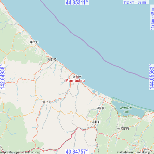
Mombetsu GPS coordinates[2]
44° 21' 9" North, 143° 21' 9" East
| Map corner | latitude | longitude |
|---|---|---|
| Upper-left | 44.85311°, | 142.64938° |
| Center: | 44.3525°, | 143.3525° |
| Lower-right: | 43.84757°, | 144.05563° |
| Map W x H: | 111.8×111.8 km | = 69.5×69.5mi |
| max Lat: | 45.40944° ⇑0.3% North |
| Mombetsu: | 44.3525° |
| min Lat: | ⇓99.7% South 24.34478° |
| min Long | Mombetsu | max Long |
| 123° | 143.3525° | 145.575° |
| W 99.4%⇐ | ⇒0.59999999999999% E |
Elevation
Elevation of Mombetsu is 16 m = 52 ft, and this is 68.6 m = 225 ft below average elevation for this country.
| Max E: |
1086 m = 3563 ft | 63.7% |
| Avg. | 84.6 m = 278 ft | |
| Mombetsu | 16 m = 52 ft | |
Min E: |
-2 m = -7 ft | 36.3% |
See also: Japan elevation on elevation.city.
Geographical zone
Mombetsu is located in North temperate zone (between Tropic of Cancer and the Arctic Circle). Distance of this Northern Tropic circle is 2325.6 km =1445.1 mi to South.| Distance of | km | miles | from Mombetsu |
|---|---|---|---|
| North Pole | 5075.5 | 3153.8 | to North |
| Arctic Circle | 2469.6 | 1534.5 | to North |
| Tropic Cancer | 2325.6 | 1445.1 | to South |
| Equator | 4931.5 | 3064.3 | to South |


Nearby cities:
15 places around Mombetsu: (largest is in red/bold)
• Abashiri
81.9 km =50.9 mi,  116°
116°
• Akabira
136.9 km =85.1 mi,  229°
229°
• Asahikawa
102 km =63.4 mi, 230°
• Ashibetsu
132.3 km =82.2 mi,  224°
224°
• Fukagawa
127.1 km =79 mi,  235°
235°
• Furano
135.9 km =84.4 mi,  214°
214°
• Kamikawa
73.5 km =45.7 mi, 219°
• Kitami
74.7 km =46.4 mi,  144°
144°
• Mobetsu
9.1 km =5.7 mi,  176°
176°
• Motomachi
83.4 km =51.8 mi,  134°
134°
• Nayoro
71.1 km =44.2 mi,  269°
269°
• Rumoi
144.1 km =89.5 mi,  251°
251°
• Shibetsu
78.8 km =49 mi,  255°
255°
• Shimo-furano
135.9 km =84.4 mi, 214°
• Utashinai
139.7 km =86.8 mi, 228°
Sources, notices
• [Note1] Compared only with cities in Japan existing in our database
• [Src1] Map data: © OpenStreetMap contributors (CC-BY-SA)
• [Src2] Other city data from geonames.org with taken over terms of usage.
• [Src3] Geographical zone / Annual Mean Temperature by Robert A. Rohde @ Wikipedia
