Mobetsu geodata
Mobetsu (Hokkaido) is a seat of a second-order administrative division; located in Japan in Asia/Tokyo (GMT+9) time zone. In our database, there are 767 cities with bigger population. Compared to other cities in Japan, 99.5% of cities are located further ↓South; 99.4% of cities are located further ←West and 57.5% of cities have higher elevation than Mobetsu. Note1


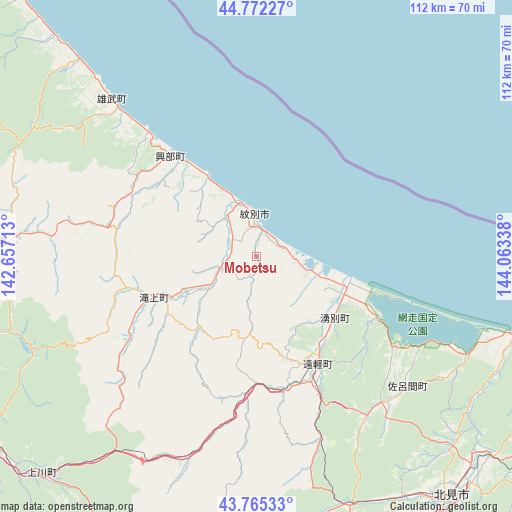
Mobetsu GPS coordinates[2]
44° 16' 15.456" North, 143° 21' 36.9" East
| Map corner | latitude | longitude |
|---|---|---|
| Upper-left | 44.77227°, | 142.65713° |
| Center: | 44.27096°, | 143.36025° |
| Lower-right: | 43.76533°, | 144.06338° |
| Map W x H: | 112×112 km | = 69.6×69.6mi |
| max Lat: | 45.40944° ⇑0.5% North |
| Mobetsu: | 44.27096° |
| min Lat: | ⇓99.5% South 24.34478° |
| min Long | Mobetsu | max Long |
| 123° | 143.36025° | 145.575° |
| W 99.4%⇐ | ⇒0.59999999999999% E |
Elevation
Elevation of Mobetsu is 21 m = 69 ft, and this is 63.6 m = 209 ft below average elevation for this country.
| Max E: |
1086 m = 3563 ft | 57.5% |
| Avg. | 84.6 m = 278 ft | |
| Mobetsu | 21 m = 69 ft | |
Min E: |
-2 m = -7 ft | 42.5% |
See also: Japan elevation on elevation.city.
Geographical zone
Mobetsu is located in North temperate zone (between Tropic of Cancer and the Arctic Circle). Distance of this Northern Tropic circle is 2316.6 km =1439.5 mi to South.| Distance of | km | miles | from Mobetsu |
|---|---|---|---|
| North Pole | 5084.6 | 3159.4 | to North |
| Arctic Circle | 2478.7 | 1540.2 | to North |
| Tropic Cancer | 2316.6 | 1439.5 | to South |
| Equator | 4922.5 | 3058.7 | to South |


Nearby cities:
15 places around Mobetsu: (largest is in red/bold)
• Abashiri
77.7 km =48.3 mi,  110°
110°
• Akabira
131.8 km =81.9 mi,  232°
232°
• Asahikawa
97.1 km =60.3 mi,  235°
235°
• Ashibetsu
126.6 km =78.7 mi, 228°
• Fukagawa
122.8 km =76.3 mi, 239°
• Furano
129 km =80.2 mi,  217°
217°
• Kamikawa
67.2 km =41.8 mi, 224°
• Kitami
67.1 km =41.7 mi,  140°
140°
• Mombetsu
9.1 km =5.7 mi,  356°
356°
• Motomachi
76.8 km =47.7 mi,  130°
130°
• Nayoro
72.3 km =44.9 mi,  277°
277°
• Shibetsu
77.7 km =48.3 mi,  261°
261°
• Shimo-furano
129 km =80.2 mi, 217°
• Takikawa
141.2 km =87.7 mi, 235°
• Utashinai
134.4 km =83.5 mi, 231°
Sources, notices
• [Note1] Compared only with cities in Japan existing in our database
• [Src1] Map data: © OpenStreetMap contributors (CC-BY-SA)
• [Src2] Other city data from geonames.org with taken over terms of usage.
• [Src3] Geographical zone / Annual Mean Temperature by Robert A. Rohde @ Wikipedia
