Taveta geodata
Taveta (Taita Taveta) is a populated place; located in Kenya in Africa/Nairobi (GMT+3) time zone. With population of 13,377 people, there are 53 cities with bigger population in this country. Compared to other cities in Kenya, 91.2% of cities are located further ↑North; 76.3% of cities are located further ←West and 81.6% of cities have higher elevation than Taveta. Note1


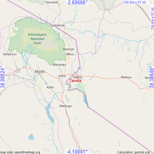
Taveta GPS coordinates[2]
3° 23' 55.644" South, 37° 41' 0.096" East
| Map corner | latitude | longitude |
|---|---|---|
| Upper-left | -2.69666°, | 36.98024° |
| Center: | -3.39879°, | 37.68336° |
| Lower-right: | -4.10041°, | 38.38649° |
| Map W x H: | 156.1×156.1 km | = 97×97mi |
| max Lat: | 3.93726° ⇑91.2% North |
| Taveta: | -3.39879° |
| min Lat: | ⇓8.8% South -4.64756° |
| min Long | Taveta | max Long |
| 33.97248° | 37.68336° | 41.85688° |
| W 76.3%⇐ | ⇒23.7% E |
Elevation
Elevation of Taveta is 753 m = 2470 ft, and this is 593.7 m = 1948 ft below average elevation for this country.
| Max E: |
2514 m = 8248 ft | 81.6% |
| Avg. | 1346.7 m = 4418 ft | |
| Taveta | 753 m = 2470 ft | |
Min E: |
7 m = 23 ft | 18.4% |
See also: Kenya elevation on elevation.city.
Geographical zone
Taveta is located in South Torrid zone (between Equator and Tropic of Capricorn). Distance of Equator is 377.9 km =234.8 mi to North.| Distance of | km | miles | from Taveta |
|---|---|---|---|
| Equator | 377.9 | 234.8 | to North |
| Tropic Capricorn | 2228 | 1384.4 | to South |
| Antarctic Circle | 7023.3 | 4364.1 | to South |
| South Pole | 9629.2 | 5983.3 | to South |


Nearby cities:
15 places around Taveta: (largest is in red/bold)
• Athi River
229.7 km =142.7 mi,  340°
340°
• Kajiado
199.3 km =123.8 mi,  329°
329°
• Kinango
198.8 km =123.5 mi,  114°
114°
• Kitui
228.8 km =142.2 mi,  9°
9°
• Konza
194.4 km =120.8 mi, 341°
• Kwale
214.3 km =133.2 mi, 113°
• Machakos
213.8 km =132.8 mi,  347°
347°
• Magadi
227.6 km =141.4 mi,  317°
317°
• Makueni Boma
177.5 km =110.3 mi,  357°
357°
• Mariakani
205.3 km =127.6 mi,  104°
104°
• Mtito Andei
95.4 km =59.3 mi,  34°
34°
• Mwatate
77.9 km =48.4 mi, 98°
• Voi
96.9 km =60.2 mi,  89°
89°
• Wote
180 km =111.8 mi, 358°
• Wundanyi
74.8 km =46.5 mi, 89°
Sources, notices
• [Note1] Compared only with cities in Kenya existing in our database
• [Src1] Map data: © OpenStreetMap contributors (CC-BY-SA)
• [Src2] Other city data from geonames.org with taken over terms of usage.
• [Src3] Geographical zone / Annual Mean Temperature by Robert A. Rohde @ Wikipedia
