Kyzyl-Kyya geodata
Kyzyl-Kyya (Batken) is a populated place; located in Kyrgyzstan in Asia/Bishkek (GMT+6) time zone. With population of 32,000 people, there are 10 cities with bigger population in this country. Compared to other cities in Kyrgyzstan, 64.3% of cities are located further ↑North; 57.1% of cities are located further →East and 57.1% of cities have higher elevation than Kyzyl-Kyya. Note1


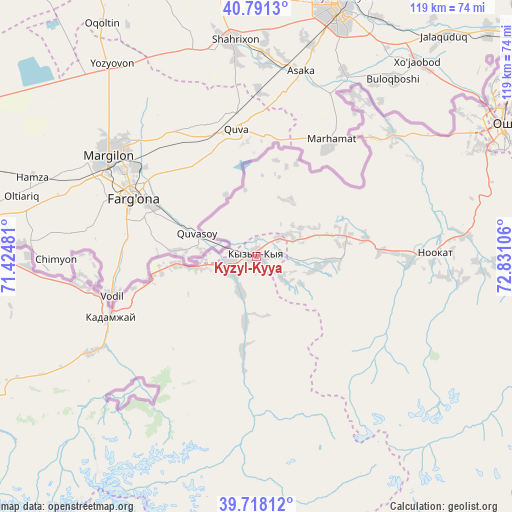
Kyzyl-Kyya GPS coordinates[2]
40° 15' 24.624" North, 72° 7' 40.548" East
| Map corner | latitude | longitude |
|---|---|---|
| Upper-left | 40.7913°, | 71.42481° |
| Center: | 40.25684°, | 72.12793° |
| Lower-right: | 39.71812°, | 72.83106° |
| Map W x H: | 119.3×119.3 km | = 74.1×74.1mi |
| max Lat: | 42.89106° ⇑64.3% North |
| Kyzyl-Kyya: | 40.25684° |
| min Lat: | ⇓35.7% South 39.55274° |
| min Long | Kyzyl-Kyya | max Long |
| 69.3716° | 72.12793° | 78.52702° |
| W 42.9%⇐ | ⇒57.1% E |
Elevation
Elevation of Kyzyl-Kyya is 999 m = 3278 ft, and this is 202.4 m = 664 ft below average elevation for this country.
| Max E: |
2638 m = 8655 ft | 57.1% |
| Avg. | 1201.4 m = 3942 ft | |
| Kyzyl-Kyya | 999 m = 3278 ft | |
Min E: |
504 m = 1654 ft | 42.9% |
See also: Kyrgyzstan elevation on elevation.city.
Geographical zone
Kyzyl-Kyya is located in North temperate zone (between Tropic of Cancer and the Arctic Circle). Distance of this Northern Tropic circle is 1870.2 km =1162.1 mi to South.| Distance of | km | miles | from Kyzyl-Kyya |
|---|---|---|---|
| North Pole | 5530.9 | 3436.7 | to North |
| Arctic Circle | 2925 | 1817.5 | to North |
| Tropic Cancer | 1870.2 | 1162.1 | to South |
| Equator | 4476.1 | 2781.3 | to South |


Nearby cities:
15 places around Kyzyl-Kyya: (largest is in red/bold)
• Alga
53.4 km =33.2 mi,  267°
267°
• Aravan
42.7 km =26.5 mi,  47°
47°
• Iradan
2.6 km =1.6 mi,  294°
294°
• Kara-Dzhygach
15.3 km =9.5 mi,  191°
191°
• Kara-Dëbë
7.2 km =4.5 mi,  258°
258°
• Karavan
6.5 km =4 mi, 49°
• Khalmion
42.3 km =26.3 mi, 263°
• Kyrgyz-Kyshtak
66.3 km =41.2 mi,  275°
275°
• Kyzyl-Bulak
40.3 km =25 mi,  235°
235°
• Markaz
19.4 km =12.1 mi, 264°
• Nookat
41.6 km =25.8 mi,  88°
88°
• Orozbekovo
44.9 km =27.9 mi, 240°
• Osh
64.3 km =40 mi,  62°
62°
• Pulgon
36 km =22.4 mi,  250°
250°
• Uch-Korgon
6.6 km =4.1 mi, 241°
Sources, notices
• [Note1] Compared only with cities in Kyrgyzstan existing in our database
• [Src1] Map data: © OpenStreetMap contributors (CC-BY-SA)
• [Src2] Other city data from geonames.org with taken over terms of usage.
• [Src3] Geographical zone / Annual Mean Temperature by Robert A. Rohde @ Wikipedia
