Iradan geodata
Iradan (Batken) is a populated place; located in Kyrgyzstan in Asia/Bishkek (GMT+6) time zone. With population of 26,200 people, there are 12 cities with bigger population in this country. Compared to other cities in Kyrgyzstan, 61.9% of cities are located further ↑North; 58.3% of cities are located further →East and 65.5% of cities have higher elevation than Iradan. Note1


Iradan GPS coordinates[2]
40° 16' 0.012" North, 72° 6' 0" East
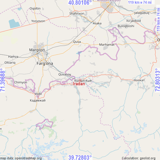
| Map corner | latitude | longitude |
|---|---|---|
| Upper-left | 40.80106°, | 71.39688° |
| Center: | 40.26667°, | 72.1° |
| Lower-right: | 39.72803°, | 72.80313° |
| Map W x H: | 119.3×119.3 km | = 74.1×74.1mi |
| max Lat: | 42.89106° ⇑61.9% North |
| Iradan: | 40.26667° |
| min Lat: | ⇓38.1% South 39.55274° |
| min Long | Iradan | max Long |
| 69.3716° | 72.1° | 78.52702° |
| W 41.7%⇐ | ⇒58.3% E |
Elevation
Elevation of Iradan is 933 m = 3061 ft, and this is 268.4 m = 881 ft below average elevation for this country.
| Max E: |
2638 m = 8655 ft | 65.5% |
| Avg. | 1201.4 m = 3942 ft | |
| Iradan | 933 m = 3061 ft | |
Min E: |
504 m = 1654 ft | 34.5% |
See also: Kyrgyzstan elevation on elevation.city.
Geographical zone
Iradan is located in North temperate zone (between Tropic of Cancer and the Arctic Circle). Distance of this Northern Tropic circle is 1871.3 km =1162.8 mi to South.| Distance of | km | miles | from Iradan |
|---|---|---|---|
| North Pole | 5529.8 | 3436.1 | to North |
| Arctic Circle | 2923.9 | 1816.8 | to North |
| Tropic Cancer | 1871.3 | 1162.8 | to South |
| Equator | 4477.2 | 2782 | to South |


Nearby cities:
15 places around Iradan: (largest is in red/bold)
• Alga
51.1 km =31.8 mi,  266°
266°
• Aravan
43.8 km =27.2 mi,  50°
50°
• Kara-Dzhygach
16.1 km =10 mi,  182°
182°
• Kara-Dëbë
5.3 km =3.3 mi,  242°
242°
• Karavan
8 km =5 mi,  66°
66°
• Khalmion
40.1 km =24.9 mi,  261°
261°
• Kyrgyz-Kyshtak
63.8 km =39.6 mi, 274°
• Kyzyl-Bulak
39 km =24.2 mi,  232°
232°
• Kyzyl-Kyya
2.6 km =1.6 mi,  114°
114°
• Markaz
17.2 km =10.7 mi, 260°
• Nookat
44 km =27.3 mi,  90°
90°
• Orozbekovo
43.4 km =27 mi, 237°
• Osh
65.9 km =40.9 mi,  63°
63°
• Pulgon
34.1 km =21.2 mi,  247°
247°
• Uch-Korgon
5.4 km =3.4 mi,  219°
219°
Sources, notices
• [Note1] Compared only with cities in Kyrgyzstan existing in our database
• [Src1] Map data: © OpenStreetMap contributors (CC-BY-SA)
• [Src2] Other city data from geonames.org with taken over terms of usage.
• [Src3] Geographical zone / Annual Mean Temperature by Robert A. Rohde @ Wikipedia
