Nookat geodata
Nookat (Osh) is a seat of a second-order administrative division; located in Kyrgyzstan in Asia/Bishkek (GMT+6) time zone. With population of 14,371 people, there are 23 cities with bigger population in this country. Compared to other cities in Kyrgyzstan, 63.1% of cities are located further ↑North; 53.6% of cities are located further ←West and 69% of cities have lower elevation than Nookat. Note1


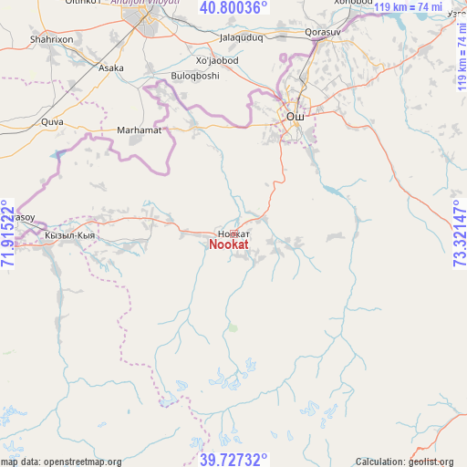
Nookat GPS coordinates[2]
40° 15' 57.492" North, 72° 37' 6.024" East
| Map corner | latitude | longitude |
|---|---|---|
| Upper-left | 40.80036°, | 71.91522° |
| Center: | 40.26597°, | 72.61834° |
| Lower-right: | 39.72732°, | 73.32147° |
| Map W x H: | 119.3×119.3 km | = 74.1×74.1mi |
| max Lat: | 42.89106° ⇑63.1% North |
| Nookat: | 40.26597° |
| min Lat: | ⇓36.9% South 39.55274° |
| min Long | Nookat | max Long |
| 69.3716° | 72.61834° | 78.52702° |
| W 53.6%⇐ | ⇒46.4% E |
Elevation
Elevation of Nookat is 1295 m = 4249 ft, and this is 93.6 m = 307 ft above average elevation for this country.
| Max E: |
2638 m = 8655 ft | 31% |
| Nookat | 1295 m 4249 ft | |
| Avg. | 1201.4 m = 3942 ft | |
Min E: |
504 m = 1654 ft | 69% |
See also: Kyrgyzstan elevation on elevation.city.
Geographical zone
Nookat is located in North temperate zone (between Tropic of Cancer and the Arctic Circle). Distance of this Northern Tropic circle is 1871.2 km =1162.7 mi to South.| Distance of | km | miles | from Nookat |
|---|---|---|---|
| North Pole | 5529.9 | 3436.1 | to North |
| Arctic Circle | 2924 | 1816.9 | to North |
| Tropic Cancer | 1871.2 | 1162.7 | to South |
| Equator | 4477.2 | 2782 | to South |


Nearby cities:
15 places around Nookat: (largest is in red/bold)
• Aravan
29.6 km =18.4 mi,  340°
340°
• Gul’cha
70.2 km =43.6 mi,  85°
85°
• Iradan
44 km =27.3 mi,  270°
270°
• Kara Suu
53.1 km =33 mi,  23°
23°
• Kara-Dzhygach
47.4 km =29.5 mi,  250°
250°
• Kara-Dëbë
48.7 km =30.3 mi, 267°
• Karavan
36.8 km =22.9 mi,  275°
275°
• Kyzyl-Bulak
78.6 km =48.8 mi, 252°
• Kyzyl-Kyya
41.6 km =25.8 mi, 268°
• Markaz
61 km =37.9 mi, 267°
• Osh
32.9 km =20.4 mi,  27°
27°
• Pulgon
76.6 km =47.6 mi,  260°
260°
• Suzak
74.3 km =46.2 mi, 18°
• Uch-Korgon
47.6 km =29.6 mi, 265°
• Uzgen
80.4 km =50 mi,  45°
45°
Sources, notices
• [Note1] Compared only with cities in Kyrgyzstan existing in our database
• [Src1] Map data: © OpenStreetMap contributors (CC-BY-SA)
• [Src2] Other city data from geonames.org with taken over terms of usage.
• [Src3] Geographical zone / Annual Mean Temperature by Robert A. Rohde @ Wikipedia
