Osh geodata
Osh is a seat of a first-order administrative division; located in Kyrgyzstan in Asia/Bishkek (GMT+6) time zone. With population of 200,000 people, there is 1 city with bigger population in this country. Compared to other cities in Kyrgyzstan, 56% of cities are located further ↑North; 58.3% of cities are located further ←West and 58.3% of cities have higher elevation than Osh. Note1


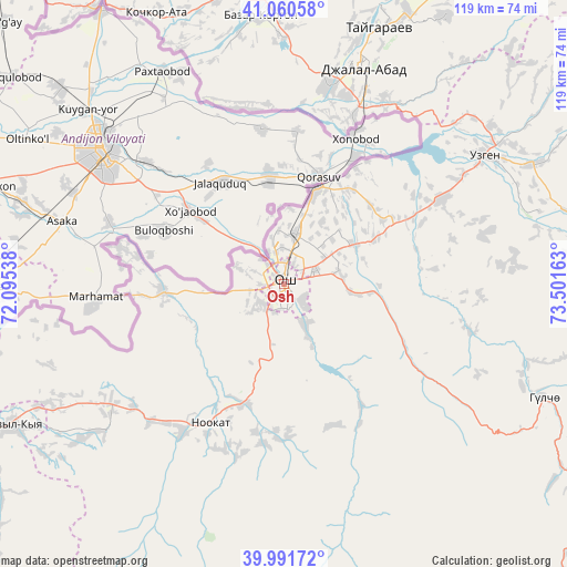
Osh GPS coordinates[2]
40° 31' 41.808" North, 72° 47' 54.6" East
| Map corner | latitude | longitude |
|---|---|---|
| Upper-left | 41.06058°, | 72.09538° |
| Center: | 40.52828°, | 72.7985° |
| Lower-right: | 39.99172°, | 73.50163° |
| Map W x H: | 118.8×118.8 km | = 73.8×73.8mi |
| max Lat: | 42.89106° ⇑56% North |
| Osh: | 40.52828° |
| min Lat: | ⇓44% South 39.55274° |
| min Long | Osh | max Long |
| 69.3716° | 72.7985° | 78.52702° |
| W 58.3%⇐ | ⇒41.7% E |
Elevation
Elevation of Osh is 988 m = 3241 ft, and this is 213.4 m = 700 ft below average elevation for this country.
| Max E: |
2638 m = 8655 ft | 58.3% |
| Avg. | 1201.4 m = 3942 ft | |
| Osh | 988 m = 3241 ft | |
Min E: |
504 m = 1654 ft | 41.7% |
See also: Osh elevation on elevation.city.
Geographical zone
Osh is located in North temperate zone (between Tropic of Cancer and the Arctic Circle). Distance of this Northern Tropic circle is 1900.4 km =1180.9 mi to South.| Distance of | km | miles | from Osh |
|---|---|---|---|
| North Pole | 5500.7 | 3418 | to North |
| Arctic Circle | 2894.9 | 1798.8 | to North |
| Tropic Cancer | 1900.4 | 1180.9 | to South |
| Equator | 4506.3 | 2800.1 | to South |


Nearby cities:
15 places around Osh: (largest is in red/bold)
• Aravan
25.3 km =15.7 mi,  266°
266°
• Bazar-Korgon
56.8 km =35.3 mi,  355°
355°
• Gul’cha
59.6 km =37 mi,  113°
113°
• Iradan
65.9 km =40.9 mi,  243°
243°
• Jalal-Abad
48.1 km =29.9 mi,  20°
20°
• Kara Suu
20.4 km =12.7 mi, 16°
• Kara-Kulja
68 km =42.3 mi,  80°
80°
• Karavan
58 km =36 mi, 243°
• Kochkor-Ata
62.5 km =38.8 mi,  334°
334°
• Kyzyl-Kyya
64.3 km =40 mi, 242°
• Massy
60.8 km =37.8 mi,  346°
346°
• Nookat
32.9 km =20.4 mi,  207°
207°
• Suzak
42.1 km =26.2 mi,  12°
12°
• Uch-Korgon
70.9 km =44.1 mi, 241°
• Uzgen
50.2 km =31.2 mi,  57°
57°
Sources, notices
• [Note1] Compared only with cities in Kyrgyzstan existing in our database
• [Src1] Map data: © OpenStreetMap contributors (CC-BY-SA)
• [Src2] Other city data from geonames.org with taken over terms of usage.
• [Src3] Geographical zone / Annual Mean Temperature by Robert A. Rohde @ Wikipedia
