Busan geodata
Busan is a seat of a first-order administrative division; located in South Korea in Asia/Seoul (GMT+9) time zone. With population of 3,678,555 people, there is 1 city with bigger population in this country. Compared to other cities in South Korea, 75.9% of cities are located further ↑North; 93% of cities are located further ←West and 65.4% of cities have higher elevation than Busan. Note1


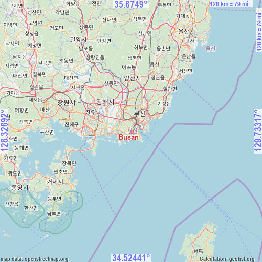
Busan GPS coordinates[2]
35° 6' 6.048" North, 129° 1' 48.144" East
| Map corner | latitude | longitude |
|---|---|---|
| Upper-left | 35.6749°, | 128.32692° |
| Center: | 35.10168°, | 129.03004° |
| Lower-right: | 34.52441°, | 129.73317° |
| Map W x H: | 127.9×127.9 km | = 79.5×79.5mi |
| max Lat: | 38.37881° ⇑75.9% North |
| Busan: | 35.10168° |
| min Lat: | ⇓24.1% South 33.25333° |
| min Long | Busan | max Long |
| 126.10863° | 129.03004° | 129.55377° |
| W 93%⇐ | ⇒7% E |
Elevation
Elevation of Busan is 26 m = 85 ft, and this is 44.4 m = 146 ft below average elevation for this country.
| Max E: |
691 m = 2267 ft | 65.4% |
| Avg. | 70.4 m = 231 ft | |
| Busan | 26 m = 85 ft | |
Min E: |
1 m = 3 ft | 34.6% |
See also: Busan elevation on elevation.city.
Geographical zone
Busan is located in North temperate zone (between Tropic of Cancer and the Arctic Circle). Distance of this Northern Tropic circle is 1297 km =805.9 mi to South.| Distance of | km | miles | from Busan |
|---|---|---|---|
| North Pole | 6104.1 | 3792.9 | to North |
| Arctic Circle | 3498.2 | 2173.7 | to North |
| Tropic Cancer | 1297 | 805.9 | to South |
| Equator | 3902.9 | 2425.1 | to South |


Nearby cities:
15 places around Busan: (largest is in red/bold)
• Changwon
34.7 km =21.6 mi,  293°
293°
• Dongnae
12.2 km =7.6 mi,  24°
24°
• Gijang
23 km =14.3 mi,  46°
46°
• Goseong
65.8 km =40.9 mi,  257°
257°
• Ilgwang
25.8 km =16 mi, 45°
• Jangan
30.4 km =18.9 mi,  39°
39°
• Kimhae
20 km =12.4 mi,  317°
317°
• Kyosai
49 km =30.4 mi,  235°
235°
• Miryang
50.5 km =31.4 mi,  329°
329°
• Naesŏ
49.2 km =30.6 mi, 289°
• Oepo
33.7 km =20.9 mi, 237°
• Sinhyeon
44.1 km =27.4 mi, 236°
• Ulsan
55 km =34.2 mi,  28°
28°
• Ungsang
36.1 km =22.4 mi, 20°
• Yangsan
26.7 km =16.6 mi,  0°
0°
Sources, notices
• [Note1] Compared only with cities in South Korea existing in our database
• [Src1] Map data: © OpenStreetMap contributors (CC-BY-SA)
• [Src2] Other city data from geonames.org with taken over terms of usage.
• [Src3] Geographical zone / Annual Mean Temperature by Robert A. Rohde @ Wikipedia
