Miryang geodata
Miryang (Gyeongsangnam-do) is a populated place; located in South Korea in Asia/Seoul (GMT+9) time zone. With population of 53,103 people, there are 84 cities with bigger population in this country. Compared to other cities in South Korea, 61.9% of cities are located further ↑North; 90.2% of cities are located further ←West and 84.3% of cities have higher elevation than Miryang. Note1


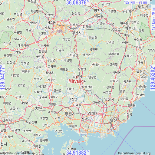
Miryang GPS coordinates[2]
35° 29' 35.988" North, 128° 44' 56.004" East
| Map corner | latitude | longitude |
|---|---|---|
| Upper-left | 36.06376°, | 128.04577° |
| Center: | 35.49333°, | 128.74889° |
| Lower-right: | 34.91882°, | 129.45202° |
| Map W x H: | 127.3×127.3 km | = 79.1×79.1mi |
| max Lat: | 38.37881° ⇑61.9% North |
| Miryang: | 35.49333° |
| min Lat: | ⇓38.1% South 33.25333° |
| min Long | Miryang | max Long |
| 126.10863° | 128.74889° | 129.55377° |
| W 90.2%⇐ | ⇒9.8% E |
Elevation
Elevation of Miryang is 14 m = 46 ft, and this is 56.4 m = 185 ft below average elevation for this country.
| Max E: |
691 m = 2267 ft | 84.3% |
| Avg. | 70.4 m = 231 ft | |
| Miryang | 14 m = 46 ft | |
Min E: |
1 m = 3 ft | 15.7% |
See also: Miryang elevation on elevation.city.
Geographical zone
Miryang is located in North temperate zone (between Tropic of Cancer and the Arctic Circle). Distance of this Northern Tropic circle is 1340.6 km =833 mi to South.| Distance of | km | miles | from Miryang |
|---|---|---|---|
| North Pole | 6060.6 | 3765.9 | to North |
| Arctic Circle | 3454.7 | 2146.7 | to North |
| Tropic Cancer | 1340.6 | 833 | to South |
| Equator | 3946.5 | 2452.2 | to South |


Nearby cities:
15 places around Miryang: (largest is in red/bold)
• Changnyeong
23.6 km =14.7 mi,  283°
283°
• Changwon
30.1 km =18.7 mi,  191°
191°
• Daegu
44.3 km =27.5 mi,  341°
341°
• Daehap
28.4 km =17.6 mi,  298°
298°
• Dongnae
44.5 km =27.7 mi,  136°
136°
• Gijang
50.4 km =31.3 mi,  123°
123°
• Gyeongsan-si
36.7 km =22.8 mi,  358°
358°
• Hayang
47.1 km =29.3 mi,  7°
7°
• Hwawŏn
41 km =25.5 mi,  326°
326°
• Hyeonpung
35.4 km =22 mi,  309°
309°
• Jangan
49 km =30.4 mi,  114°
114°
• Kimhae
31.2 km =19.4 mi,  157°
157°
• Naesŏ
34.1 km =21.2 mi,  217°
217°
• Ungsang
39.2 km =24.4 mi,  104°
104°
• Yangsan
30.8 km =19.1 mi, 123°
Sources, notices
• [Note1] Compared only with cities in South Korea existing in our database
• [Src1] Map data: © OpenStreetMap contributors (CC-BY-SA)
• [Src2] Other city data from geonames.org with taken over terms of usage.
• [Src3] Geographical zone / Annual Mean Temperature by Robert A. Rohde @ Wikipedia
