Dongnae geodata
Dongnae (Busan) is a seat of a second-order administrative division; located in South Korea in Asia/Seoul (GMT+9) time zone. In our database, there are 128 cities with bigger population. Compared to other cities in South Korea, 73.4% of cities are located further ↑North; 94.1% of cities are located further ←West and 89.9% of cities have higher elevation than Dongnae. Note1


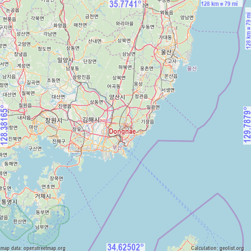
Dongnae GPS coordinates[2]
35° 12' 5.724" North, 129° 5' 5.172" East
| Map corner | latitude | longitude |
|---|---|---|
| Upper-left | 35.7741°, | 128.38165° |
| Center: | 35.20159°, | 129.08477° |
| Lower-right: | 34.62502°, | 129.7879° |
| Map W x H: | 127.8×127.8 km | = 79.4×79.4mi |
| max Lat: | 38.37881° ⇑73.4% North |
| Dongnae: | 35.20159° |
| min Lat: | ⇓26.6% South 33.25333° |
| min Long | Dongnae | max Long |
| 126.10863° | 129.08477° | 129.55377° |
| W 94.1%⇐ | ⇒5.9% E |
Elevation
Elevation of Dongnae is 11 m = 36 ft, and this is 59.4 m = 195 ft below average elevation for this country.
| Max E: |
691 m = 2267 ft | 89.9% |
| Avg. | 70.4 m = 231 ft | |
| Dongnae | 11 m = 36 ft | |
Min E: |
1 m = 3 ft | 10.1% |
See also: South Korea elevation on elevation.city.
Geographical zone
Dongnae is located in North temperate zone (between Tropic of Cancer and the Arctic Circle). Distance of this Northern Tropic circle is 1308.1 km =812.8 mi to South.| Distance of | km | miles | from Dongnae |
|---|---|---|---|
| North Pole | 6093 | 3786 | to North |
| Arctic Circle | 3487.1 | 2166.8 | to North |
| Tropic Cancer | 1308.1 | 812.8 | to South |
| Equator | 3914 | 2432 | to South |


Nearby cities:
15 places around Dongnae: (largest is in red/bold)
• Busan
12.2 km =7.6 mi,  204°
204°
• Changnyeong
65.5 km =40.7 mi,  305°
305°
• Changwon
36.8 km =22.9 mi,  274°
274°
• Gijang
12.6 km =7.8 mi,  68°
68°
• Ilgwang
15.2 km =9.4 mi,  62°
62°
• Jangan
18.9 km =11.7 mi,  49°
49°
• Kimhae
18.9 km =11.7 mi,  281°
281°
• Kyosai
59.7 km =37.1 mi,  229°
229°
• Miryang
44.5 km =27.7 mi,  316°
316°
• Naesŏ
51.6 km =32.1 mi, 275°
• Oepo
44.3 km =27.5 mi, 229°
• Sinhyeon
54.8 km =34.1 mi, 229°
• Ulsan
42.8 km =26.6 mi,  29°
29°
• Ungsang
24 km =14.9 mi,  18°
18°
• Yangsan
16.3 km =10.1 mi,  343°
343°
Sources, notices
• [Note1] Compared only with cities in South Korea existing in our database
• [Src1] Map data: © OpenStreetMap contributors (CC-BY-SA)
• [Src2] Other city data from geonames.org with taken over terms of usage.
• [Src3] Geographical zone / Annual Mean Temperature by Robert A. Rohde @ Wikipedia
