Hongseong geodata
Hongseong (Chungcheongnam-do) is a seat of a first-order administrative division; located in South Korea in Asia/Seoul (GMT+9) time zone. With population of 89,174 people, there are 52 cities with bigger population in this country. Compared to other cities in South Korea, 68.5% of cities are located further ↓South; 82.2% of cities are located further →East and 59.1% of cities have higher elevation than Hongseong. Note1


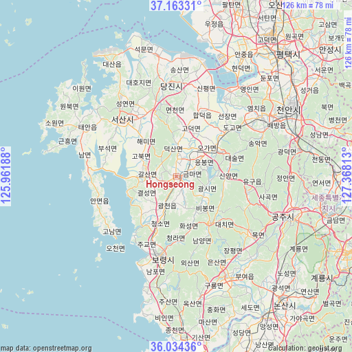
Hongseong GPS coordinates[2]
36° 36' 3.24" North, 126° 39' 54" East
| Map corner | latitude | longitude |
|---|---|---|
| Upper-left | 37.16331°, | 125.96188° |
| Center: | 36.6009°, | 126.665° |
| Lower-right: | 36.03436°, | 127.36813° |
| Map W x H: | 125.5×125.5 km | = 78×78mi |
| max Lat: | 38.37881° ⇑31.5% North |
| Hongseong: | 36.6009° |
| min Lat: | ⇓68.5% South 33.25333° |
| min Long | Hongseong | max Long |
| 126.10863° | 126.665° | 129.55377° |
| W 17.8%⇐ | ⇒82.2% E |
Elevation
Elevation of Hongseong is 31 m = 102 ft, and this is 39.4 m = 129 ft below average elevation for this country.
| Max E: |
691 m = 2267 ft | 59.1% |
| Avg. | 70.4 m = 231 ft | |
| Hongseong | 31 m = 102 ft | |
Min E: |
1 m = 3 ft | 40.9% |
See also: Hongseong elevation on elevation.city.
Geographical zone
Hongseong is located in North temperate zone (between Tropic of Cancer and the Arctic Circle). Distance of this Northern Tropic circle is 1463.7 km =909.5 mi to South.| Distance of | km | miles | from Hongseong |
|---|---|---|---|
| North Pole | 5937.4 | 3689.3 | to North |
| Arctic Circle | 3331.5 | 2070.1 | to North |
| Tropic Cancer | 1463.7 | 909.5 | to South |
| Equator | 4069.6 | 2528.7 | to South |


Nearby cities:
15 places around Hongseong: (largest is in red/bold)
• Asan
36.4 km =22.6 mi,  56°
56°
• Biin
51.5 km =32 mi,  186°
186°
• Boryeong
28.6 km =17.8 mi, 192°
• Buyeo
42.3 km =26.3 mi,  148°
148°
• Cheonan
49.1 km =30.5 mi, 62°
• Cheongnam
37.6 km =23.4 mi,  136°
136°
• Cheongyang
20.7 km =12.9 mi, 143°
• Gongju
44.1 km =27.4 mi,  111°
111°
• Gyuam
41.2 km =25.6 mi, 151°
• Jangpyeong
35.3 km =21.9 mi, 144°
• Seonghwan
54.3 km =33.7 mi,  49°
49°
• Seosan
27.6 km =17.1 mi,  316°
316°
• Taesal-li
45.3 km =28.1 mi,  335°
335°
• Tangjin
32.8 km =20.4 mi,  354°
354°
• Yesan
18 km =11.2 mi, 61°
Sources, notices
• [Note1] Compared only with cities in South Korea existing in our database
• [Src1] Map data: © OpenStreetMap contributors (CC-BY-SA)
• [Src2] Other city data from geonames.org with taken over terms of usage.
• [Src3] Geographical zone / Annual Mean Temperature by Robert A. Rohde @ Wikipedia
