Cheongpyeong geodata
Cheongpyeong (Gyeonggi-do) is a seat of a third-order administrative division; located in South Korea in Asia/Seoul (GMT+9) time zone. In our database, there are 128 cities with bigger population. Compared to other cities in South Korea, 89.2% of cities are located further ↓South; 56.3% of cities are located further ←West and 51% of cities have lower elevation than Cheongpyeong. Note1


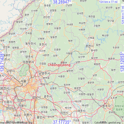
Cheongpyeong GPS coordinates[2]
37° 44' 7.8" North, 127° 25' 2.64" East
| Map corner | latitude | longitude |
|---|---|---|
| Upper-left | 38.28947°, | 126.71428° |
| Center: | 37.7355°, | 127.4174° |
| Lower-right: | 37.17735°, | 128.12053° |
| Map W x H: | 123.7×123.7 km | = 76.9×76.9mi |
| max Lat: | 38.37881° ⇑10.8% North |
| Cheongpyeong: | 37.7355° |
| min Lat: | ⇓89.2% South 33.25333° |
| min Long | Cheongpyeong | max Long |
| 126.10863° | 127.4174° | 129.55377° |
| W 56.3%⇐ | ⇒43.7% E |
Elevation
Elevation of Cheongpyeong is 44 m = 144 ft, and this is 26.4 m = 87 ft below average elevation for this country.
| Max E: |
691 m = 2267 ft | 49% |
| Avg. | 70.4 m = 231 ft | |
| Cheongpyeong | 44 m = 144 ft | |
Min E: |
1 m = 3 ft | 51% |
See also: South Korea elevation on elevation.city.
Geographical zone
Cheongpyeong is located in North temperate zone (between Tropic of Cancer and the Arctic Circle). Distance of this Northern Tropic circle is 1589.9 km =987.9 mi to South.| Distance of | km | miles | from Cheongpyeong |
|---|---|---|---|
| North Pole | 5811.3 | 3611 | to North |
| Arctic Circle | 3205.4 | 1991.7 | to North |
| Tropic Cancer | 1589.9 | 987.9 | to South |
| Equator | 4195.8 | 2607.1 | to South |


Nearby cities:
15 places around Cheongpyeong: (largest is in red/bold)
• Chuncheon
31.8 km =19.8 mi,  60°
60°
• Dongnae
32.7 km =20.3 mi,  67°
67°
• Gapyeong
13.4 km =8.3 mi,  37°
37°
• Guri-si
28.8 km =17.9 mi,  238°
238°
• Hanam
28.6 km =17.8 mi,  220°
220°
• Hwado
13.4 km =8.3 mi,  226°
226°
• Jinjeop
20 km =12.4 mi,  267°
267°
• Namyangju
21 km =13 mi, 238°
• Onam
19.1 km =11.9 mi,  257°
257°
• Sindong
27.8 km =17.3 mi, 70°
• Su-dong
8.8 km =5.5 mi,  246°
246°
• Uijeongbu-si
32.5 km =20.2 mi, 271°
• Wabu
23.7 km =14.7 mi, 226°
• Yangju
33.1 km =20.6 mi,  289°
289°
• Yangp'yŏng
28.1 km =17.5 mi,  166°
166°
Sources, notices
• [Note1] Compared only with cities in South Korea existing in our database
• [Src1] Map data: © OpenStreetMap contributors (CC-BY-SA)
• [Src2] Other city data from geonames.org with taken over terms of usage.
• [Src3] Geographical zone / Annual Mean Temperature by Robert A. Rohde @ Wikipedia
