Aktau geodata
Aktau (Karaganda) is a populated place; located in Kazakhstan in Asia/Almaty (GMT+5) time zone. With population of 9,977 people, there are 113 cities with bigger population in this country. Compared to other cities in Kazakhstan, 55.2% of cities are located further ↑North; 61.5% of cities are located further ←West and 93% of cities have lower elevation than Aktau. Note1


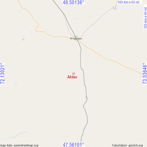
Aktau GPS coordinates[2]
48° 1' 59.988" North, 72° 49' 59.988" East
| Map corner | latitude | longitude |
|---|---|---|
| Upper-left | 48.50136°, | 72.13021° |
| Center: | 48.03333°, | 72.83333° |
| Lower-right: | 47.56101°, | 73.53646° |
| Map W x H: | 104.6×104.6 km | = 65×65mi |
| max Lat: | 54.90596° ⇑55.2% North |
| Aktau: | 48.03333° |
| min Lat: | ⇓44.8% South 40.66338° |
| min Long | Aktau | max Long |
| 46.83361° | 72.83333° | 84.87144° |
| W 61.5%⇐ | ⇒38.5% E |
Elevation
Elevation of Aktau is 765 m = 2510 ft, and this is 408.5 m = 1340 ft above average elevation for this country.
| Max E: |
1847 m = 6060 ft | 7% |
| Aktau | 765 m 2510 ft | |
| Avg. | 356.5 m = 1170 ft | |
Min E: |
-26 m = -85 ft | 93% |
See also: Kazakhstan elevation on elevation.city.
Geographical zone
Aktau is located in North temperate zone (between Tropic of Cancer and the Arctic Circle). Distance of this North polar circle is 2060.4 km =1280.3 mi to North.| Distance of | km | miles | from Aktau |
|---|---|---|---|
| North Pole | 4666.3 | 2899.5 | to North |
| Arctic Circle | 2060.4 | 1280.3 | to North |
| Tropic Cancer | 2734.9 | 1699.4 | to South |
| Equator | 5340.8 | 3318.6 | to South |


Nearby cities:
15 places around Aktau: (largest is in red/bold)
• Abay
178.2 km =110.7 mi,  0°
0°
• Aksu-Ayuly
102.5 km =63.7 mi,  37°
37°
• Aktogay
183.8 km =114.2 mi,  85°
85°
• Aqadyr
25.3 km =15.7 mi, 4°
• Aqshataū
91.2 km =56.7 mi, 93°
• Atasū
114 km =70.8 mi,  309°
309°
• Dolinka
183.1 km =113.8 mi,  356°
356°
• Koktal
186.6 km =115.9 mi,  15°
15°
• Moyynty
98.8 km =61.4 mi,  156°
156°
• Novodolinskiy
186.3 km =115.8 mi, 357°
• Qarazhal
151.5 km =94.1 mi,  268°
268°
• Shakhtinsk
187.1 km =116.3 mi,  354°
354°
• Verkhniye Kayrakty
79.6 km =49.5 mi, 24°
• Zhambyl
141.5 km =87.9 mi,  229°
229°
• Zharyk
91.6 km =56.9 mi, 0°
Sources, notices
• [Note1] Compared only with cities in Kazakhstan existing in our database
• [Src1] Map data: © OpenStreetMap contributors (CC-BY-SA)
• [Src2] Other city data from geonames.org with taken over terms of usage.
• [Src3] Geographical zone / Annual Mean Temperature by Robert A. Rohde @ Wikipedia
