Aqadyr geodata
Aqadyr (Karaganda) is a populated place; located in Kazakhstan in Asia/Almaty (GMT+5) time zone. With population of 9,710 people, there are 121 cities with bigger population in this country. Compared to other cities in Kazakhstan, 54.1% of cities are located further ↑North; 62.6% of cities are located further ←West and 90% of cities have lower elevation than Aqadyr. Note1


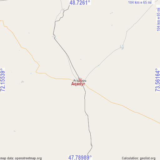
Aqadyr GPS coordinates[2]
48° 15' 36.504" North, 72° 51' 30.636" East
| Map corner | latitude | longitude |
|---|---|---|
| Upper-left | 48.7261°, | 72.15539° |
| Center: | 48.26014°, | 72.85851° |
| Lower-right: | 47.78989°, | 73.56164° |
| Map W x H: | 104.1×104.1 km | = 64.7×64.7mi |
| max Lat: | 54.90596° ⇑54.1% North |
| Aqadyr: | 48.26014° |
| min Lat: | ⇓45.9% South 40.66338° |
| min Long | Aqadyr | max Long |
| 46.83361° | 72.85851° | 84.87144° |
| W 62.6%⇐ | ⇒37.4% E |
Elevation
Elevation of Aqadyr is 693 m = 2274 ft, and this is 336.5 m = 1104 ft above average elevation for this country.
| Max E: |
1847 m = 6060 ft | 10% |
| Aqadyr | 693 m 2274 ft | |
| Avg. | 356.5 m = 1170 ft | |
Min E: |
-26 m = -85 ft | 90% |
See also: Kazakhstan elevation on elevation.city.
Geographical zone
Aqadyr is located in North temperate zone (between Tropic of Cancer and the Arctic Circle). Distance of this North polar circle is 2035.1 km =1264.6 mi to North.| Distance of | km | miles | from Aqadyr |
|---|---|---|---|
| North Pole | 4641 | 2883.8 | to North |
| Arctic Circle | 2035.1 | 1264.6 | to North |
| Tropic Cancer | 2760.1 | 1715 | to South |
| Equator | 5366 | 3334.3 | to South |


Nearby cities:
15 places around Aqadyr: (largest is in red/bold)
• Abay
153 km =95.1 mi,  0°
0°
• Aksu-Ayuly
82.4 km =51.2 mi,  46°
46°
• Aktas
169.1 km =105.1 mi, 2°
• Aktau
25.3 km =15.7 mi,  184°
184°
• Aqshataū
94 km =58.4 mi,  108°
108°
• Atasū
101.3 km =62.9 mi,  297°
297°
• Dolinka
158.1 km =98.2 mi,  355°
355°
• Koktal
161.8 km =100.5 mi,  17°
17°
• Moyynty
121.6 km =75.6 mi,  161°
161°
• Novodolinskiy
161.2 km =100.2 mi, 356°
• Qarazhal
155.6 km =96.7 mi,  259°
259°
• Shakhtinsk
162.2 km =100.8 mi,  353°
353°
• Verkhniye Kayrakty
56.5 km =35.1 mi,  33°
33°
• Zhambyl
160.2 km =99.5 mi,  223°
223°
• Zharyk
66.4 km =41.3 mi, 358°
Sources, notices
• [Note1] Compared only with cities in Kazakhstan existing in our database
• [Src1] Map data: © OpenStreetMap contributors (CC-BY-SA)
• [Src2] Other city data from geonames.org with taken over terms of usage.
• [Src3] Geographical zone / Annual Mean Temperature by Robert A. Rohde @ Wikipedia
