Minuwangoda geodata
Minuwangoda (Western) is a populated place; located in Sri Lanka in Asia/Colombo (GMT+5.5) time zone. With population of 7,772 people, there are 62 cities with bigger population in this country. Compared to other cities in Sri Lanka, 64.5% of cities are located further ↓South; 71.1% of cities are located further →East and 51.3% of cities have lower elevation than Minuwangoda. Note1
Administrative division(s):
- Level 1: Western
- Level 2: Gampaha District
- Level 3: Minuwangoda Division
- Level 4: Wattegedara


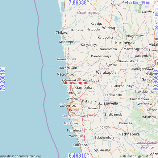
Minuwangoda GPS coordinates[2]
7° 9' 58.68" North, 79° 57' 11.88" East
| Map corner | latitude | longitude |
|---|---|---|
| Upper-left | 7.86338°, | 79.25018° |
| Center: | 7.1663°, | 79.9533° |
| Lower-right: | 6.46815°, | 80.65643° |
| Map W x H: | 155.1×155.1 km | = 96.4×96.4mi |
| max Lat: | 9.81667° ⇑35.5% North |
| Minuwangoda: | 7.1663° |
| min Lat: | ⇓64.5% South 5.92825° |
| min Long | Minuwangoda | max Long |
| 79.79528° | 79.9533° | 81.83472° |
| W 28.9%⇐ | ⇒71.1% E |
Elevation
Elevation of Minuwangoda is 18 m = 59 ft, and this is 139.4 m = 457 ft below average elevation for this country.
| Max E: |
1868 m = 6129 ft | 48.7% |
| Avg. | 157.4 m = 516 ft | |
| Minuwangoda | 18 m = 59 ft | |
Min E: |
1 m = 3 ft | 51.3% |
See also: Sri Lanka elevation on elevation.city.
Geographical zone
Minuwangoda is located in North Torrid zone (between Equator and Tropic of Cancer). Distance of Equator is 796.8 km =495.1 mi to South.| Distance of | km | miles | from Minuwangoda |
|---|---|---|---|
| North Pole | 9210.2 | 5723 | to North |
| Arctic Circle | 6604.4 | 4103.8 | to North |
| Tropic Cancer | 1809.1 | 1124.1 | to North |
| Equator | 796.8 | 495.1 | to South |


Nearby cities:
15 places around Minuwangoda: (largest is in red/bold)
• Battaramulla South
30.3 km =18.8 mi,  187°
187°
• Colombo
28.1 km =17.5 mi,  204°
204°
• Gampaha
9.6 km =6 mi,  153°
153°
• Hendala
21 km =13 mi, 201°
• Ja Ela
12.3 km =7.6 mi,  213°
213°
• Kandana
14.7 km =9.1 mi, 206°
• Katunayaka
7.2 km =4.5 mi,  273°
273°
• Kelaniya
23.7 km =14.7 mi, 188°
• Kolonnawa
27 km =16.8 mi, 196°
• Kotikawatta
27.1 km =16.8 mi, 190°
• Mulleriyawa
26.1 km =16.2 mi, 185°
• Negombo
13.8 km =8.6 mi,  289°
289°
• Peliyagoda
23.3 km =14.5 mi, 199°
• Wattala
20.8 km =12.9 mi, 199°
• Welisara
16.4 km =10.2 mi, 200°
Sources, notices
• [Note1] Compared only with cities in Sri Lanka existing in our database
• [Src1] Map data: © OpenStreetMap contributors (CC-BY-SA)
• [Src2] Other city data from geonames.org with taken over terms of usage.
• [Src3] Geographical zone / Annual Mean Temperature by Robert A. Rohde @ Wikipedia
