Katunayaka geodata
Katunayaka (Western) is a seat of a third-order administrative division; located in Sri Lanka in Asia/Colombo (GMT+5.5) time zone. With population of 84,643 people, there are 13 cities with bigger population in this country. Compared to other cities in Sri Lanka, 65.8% of cities are located further ↓South; 88.2% of cities are located further →East and 60.5% of cities have higher elevation than Katunayaka. Note1


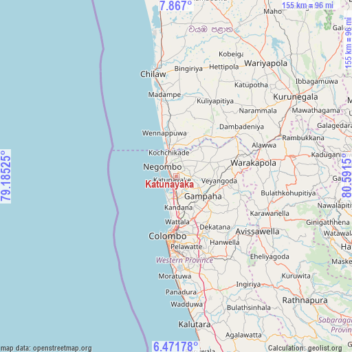
Katunayaka GPS coordinates[2]
7° 10' 11.712" North, 79° 53' 18.132" East
| Map corner | latitude | longitude |
|---|---|---|
| Upper-left | 7.867°, | 79.18525° |
| Center: | 7.16992°, | 79.88837° |
| Lower-right: | 6.47178°, | 80.5915° |
| Map W x H: | 155.1×155.1 km | = 96.4×96.4mi |
| max Lat: | 9.81667° ⇑34.2% North |
| Katunayaka: | 7.16992° |
| min Lat: | ⇓65.8% South 5.92825° |
| min Long | Katunayaka | max Long |
| 79.79528° | 79.88837° | 81.83472° |
| W 11.8%⇐ | ⇒88.2% E |
Elevation
Elevation of Katunayaka is 13 m = 43 ft, and this is 144.4 m = 474 ft below average elevation for this country.
| Max E: |
1868 m = 6129 ft | 60.5% |
| Avg. | 157.4 m = 516 ft | |
| Katunayaka | 13 m = 43 ft | |
Min E: |
1 m = 3 ft | 39.5% |
See also: Katunayaka elevation on elevation.city.
Geographical zone
Katunayaka is located in North Torrid zone (between Equator and Tropic of Cancer). Distance of Equator is 797.2 km =495.4 mi to South.| Distance of | km | miles | from Katunayaka |
|---|---|---|---|
| North Pole | 9209.8 | 5722.7 | to North |
| Arctic Circle | 6604 | 4103.5 | to North |
| Tropic Cancer | 1808.7 | 1123.9 | to North |
| Equator | 797.2 | 495.4 | to South |


Nearby cities:
15 places around Katunayaka: (largest is in red/bold)
• Battaramulla South
30.6 km =19 mi,  173°
173°
• Colombo
26.4 km =16.4 mi,  189°
189°
• Gampaha
14.5 km =9 mi,  127°
127°
• Hendala
19.9 km =12.4 mi,  181°
181°
• Ja Ela
10.6 km =6.6 mi, 177°
• Kandana
13.6 km =8.5 mi, 177°
• Kelaniya
24.2 km =15 mi, 171°
• Kolonnawa
26.4 km =16.4 mi, 180°
• Kotikawatta
27.1 km =16.8 mi, 175°
• Minuwangoda
7.2 km =4.5 mi,  93°
93°
• Mulleriyawa
26.7 km =16.6 mi, 170°
• Negombo
7.2 km =4.5 mi,  306°
306°
• Peliyagoda
22.4 km =13.9 mi, 181°
• Wattala
20.1 km =12.5 mi, 178°
• Welisara
15.8 km =9.8 mi, 174°
Sources, notices
• [Note1] Compared only with cities in Sri Lanka existing in our database
• [Src1] Map data: © OpenStreetMap contributors (CC-BY-SA)
• [Src2] Other city data from geonames.org with taken over terms of usage.
• [Src3] Geographical zone / Annual Mean Temperature by Robert A. Rohde @ Wikipedia
