Bentota geodata
Bentota (Southern) is a populated place; located in Sri Lanka in Asia/Colombo (GMT+5.5) time zone. With population of 37,000 people, there are 30 cities with bigger population in this country. Compared to other cities in Sri Lanka, 84.2% of cities are located further ↑North; 65.8% of cities are located further →East and 88.2% of cities have higher elevation than Bentota. Note1


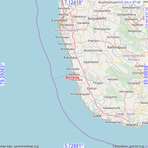
Bentota GPS coordinates[2]
6° 25' 33.528" North, 79° 59' 44.7" East
| Map corner | latitude | longitude |
|---|---|---|
| Upper-left | 7.12419°, | 79.29263° |
| Center: | 6.42598°, | 79.99575° |
| Lower-right: | 5.72681°, | 80.69888° |
| Map W x H: | 155.4×155.4 km | = 96.6×96.6mi |
| max Lat: | 9.81667° ⇑84.2% North |
| Bentota: | 6.42598° |
| min Lat: | ⇓15.8% South 5.92825° |
| min Long | Bentota | max Long |
| 79.79528° | 79.99575° | 81.83472° |
| W 34.2%⇐ | ⇒65.8% E |
Elevation
Elevation of Bentota is 8 m = 26 ft, and this is 149.4 m = 490 ft below average elevation for this country.
| Max E: |
1868 m = 6129 ft | 88.2% |
| Avg. | 157.4 m = 516 ft | |
| Bentota | 8 m = 26 ft | |
Min E: |
1 m = 3 ft | 11.8% |
See also: Sri Lanka elevation on elevation.city.
Geographical zone
Bentota is located in North Torrid zone (between Equator and Tropic of Cancer). Distance of Equator is 714.5 km =444 mi to South.| Distance of | km | miles | from Bentota |
|---|---|---|---|
| North Pole | 9292.6 | 5774.2 | to North |
| Arctic Circle | 6686.7 | 4154.9 | to North |
| Tropic Cancer | 1891.4 | 1175.3 | to North |
| Equator | 714.5 | 444 | to South |


Nearby cities:
15 places around Bentota: (largest is in red/bold)
• Ambalangoda
22.1 km =13.7 mi,  163°
163°
• Battaramulla South
53 km =32.9 mi,  350°
350°
• Beruwala
6 km =3.7 mi, 346°
• Dehiwala-Mount Lavinia
48.1 km =29.9 mi,  343°
343°
• Galle
48.4 km =30.1 mi,  150°
150°
• Hikkaduwa
33.8 km =21 mi, 159°
• Homagama
46.5 km =28.9 mi,  0°
0°
• Horana South
33.1 km =20.6 mi,  12°
12°
• Horawala Junction
15.7 km =9.8 mi,  67°
67°
• Kalutara
17.9 km =11.1 mi, 347°
• Maharagama
47.5 km =29.5 mi, 350°
• Moratuwa
40.6 km =25.2 mi, 341°
• Panadura
33.6 km =20.9 mi, 342°
• Pita Kotte
52.7 km =32.7 mi, 348°
• Sri Jayewardenepura Kotte
51.7 km =32.1 mi, 349°
Sources, notices
• [Note1] Compared only with cities in Sri Lanka existing in our database
• [Src1] Map data: © OpenStreetMap contributors (CC-BY-SA)
• [Src2] Other city data from geonames.org with taken over terms of usage.
• [Src3] Geographical zone / Annual Mean Temperature by Robert A. Rohde @ Wikipedia
