Ambalangoda geodata
Ambalangoda (Southern) is a populated place; located in Sri Lanka in Asia/Colombo (GMT+5.5) time zone. With population of 20,133 people, there are 50 cities with bigger population in this country. Compared to other cities in Sri Lanka, 86.8% of cities are located further ↑North; 60.5% of cities are located further →East and 60.5% of cities have higher elevation than Ambalangoda. Note1
Administrative division(s):
- Level 1: Southern
- Level 2: Galle District
- Level 3: Ambalangoda
- Level 4: Patabendimulla


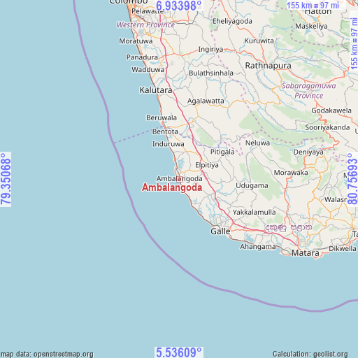
Ambalangoda GPS coordinates[2]
6° 14' 7.8" North, 80° 3' 13.68" East
| Map corner | latitude | longitude |
|---|---|---|
| Upper-left | 6.93398°, | 79.35068° |
| Center: | 6.2355°, | 80.0538° |
| Lower-right: | 5.53609°, | 80.75693° |
| Map W x H: | 155.4×155.4 km | = 96.6×96.6mi |
| max Lat: | 9.81667° ⇑86.8% North |
| Ambalangoda: | 6.2355° |
| min Lat: | ⇓13.2% South 5.92825° |
| min Long | Ambalangoda | max Long |
| 79.79528° | 80.0538° | 81.83472° |
| W 39.5%⇐ | ⇒60.5% E |
Elevation
Elevation of Ambalangoda is 13 m = 43 ft, and this is 144.4 m = 474 ft below average elevation for this country.
| Max E: |
1868 m = 6129 ft | 60.5% |
| Avg. | 157.4 m = 516 ft | |
| Ambalangoda | 13 m = 43 ft | |
Min E: |
1 m = 3 ft | 39.5% |
See also: Sri Lanka elevation on elevation.city.
Geographical zone
Ambalangoda is located in North Torrid zone (between Equator and Tropic of Cancer). Distance of Equator is 693.3 km =430.8 mi to South.| Distance of | km | miles | from Ambalangoda |
|---|---|---|---|
| North Pole | 9313.7 | 5787.3 | to North |
| Arctic Circle | 6707.9 | 4168.1 | to North |
| Tropic Cancer | 1912.6 | 1188.4 | to North |
| Equator | 693.3 | 430.8 | to South |


Nearby cities:
15 places around Ambalangoda: (largest is in red/bold)
• Bentota
22.1 km =13.7 mi,  343°
343°
• Beruwala
28.2 km =17.5 mi, 343°
• Galle
27.3 km =17 mi,  140°
140°
• Hikkaduwa
11.8 km =7.3 mi,  153°
153°
• Horana South
53.4 km =33.2 mi,  1°
1°
• Horawala Junction
28.5 km =17.7 mi,  16°
16°
• Kalutara
40 km =24.9 mi, 344°
• Koggala
40.9 km =25.4 mi,  132°
132°
• Matara
62.1 km =38.6 mi,  120°
120°
• Mirissa city
55.1 km =34.2 mi, 125°
• Moratuwa
62.7 km =39 mi, 342°
• Panadura
55.7 km =34.6 mi, 342°
• Talpe
36.1 km =22.4 mi, 136°
• Unawatuna
32.2 km =20 mi, 137°
• Weligama
50.7 km =31.5 mi, 124°
Sources, notices
• [Note1] Compared only with cities in Sri Lanka existing in our database
• [Src1] Map data: © OpenStreetMap contributors (CC-BY-SA)
• [Src2] Other city data from geonames.org with taken over terms of usage.
• [Src3] Geographical zone / Annual Mean Temperature by Robert A. Rohde @ Wikipedia
