Hikkaduwa geodata
Hikkaduwa (Southern) is a populated place; located in Sri Lanka in Asia/Colombo (GMT+5.5) time zone. With population of 1,300 people, there are 73 cities with bigger population in this country. Compared to other cities in Sri Lanka, 88.2% of cities are located further ↑North; 56.6% of cities are located further →East and 88.2% of cities have higher elevation than Hikkaduwa. Note1
Administrative division(s):
- Level 1: Southern
- Level 2: Galle District
- Level 3: Hikkaduwa
- Level 4: Hikkaduwa Nagarikaya


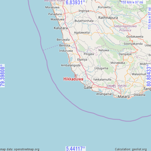
Hikkaduwa GPS coordinates[2]
6° 8' 26.52" North, 80° 6' 4.32" East
| Map corner | latitude | longitude |
|---|---|---|
| Upper-left | 6.83931°, | 79.39808° |
| Center: | 6.1407°, | 80.1012° |
| Lower-right: | 5.44117°, | 80.80433° |
| Map W x H: | 155.5×155.5 km | = 96.6×96.6mi |
| max Lat: | 9.81667° ⇑88.2% North |
| Hikkaduwa: | 6.1407° |
| min Lat: | ⇓11.8% South 5.92825° |
| min Long | Hikkaduwa | max Long |
| 79.79528° | 80.1012° | 81.83472° |
| W 43.4%⇐ | ⇒56.6% E |
Elevation
Elevation of Hikkaduwa is 8 m = 26 ft, and this is 149.4 m = 490 ft below average elevation for this country.
| Max E: |
1868 m = 6129 ft | 88.2% |
| Avg. | 157.4 m = 516 ft | |
| Hikkaduwa | 8 m = 26 ft | |
Min E: |
1 m = 3 ft | 11.8% |
See also: Sri Lanka elevation on elevation.city.
Geographical zone
Hikkaduwa is located in North Torrid zone (between Equator and Tropic of Cancer). Distance of Equator is 682.8 km =424.3 mi to South.| Distance of | km | miles | from Hikkaduwa |
|---|---|---|---|
| North Pole | 9324.3 | 5793.8 | to North |
| Arctic Circle | 6718.4 | 4174.6 | to North |
| Tropic Cancer | 1923.1 | 1195 | to North |
| Equator | 682.8 | 424.3 | to South |


Nearby cities:
15 places around Hikkaduwa: (largest is in red/bold)
• Ambalangoda
11.8 km =7.3 mi,  333°
333°
• Bentota
33.8 km =21 mi,  339°
339°
• Beruwala
39.8 km =24.7 mi, 340°
• Devinuwara
58.9 km =36.6 mi,  113°
113°
• Galle
16 km =9.9 mi,  131°
131°
• Horana South
64.1 km =39.8 mi,  356°
356°
• Horawala Junction
37.9 km =23.5 mi,  4°
4°
• Kalutara
51.6 km =32.1 mi, 342°
• Koggala
30.3 km =18.8 mi,  123°
123°
• Matara
52.5 km =32.6 mi, 113°
• Mirissa city
45 km =28 mi, 118°
• Panadura
67.3 km =41.8 mi, 340°
• Talpe
25.1 km =15.6 mi, 128°
• Unawatuna
21.2 km =13.2 mi, 128°
• Weligama
40.7 km =25.3 mi, 116°
Sources, notices
• [Note1] Compared only with cities in Sri Lanka existing in our database
• [Src1] Map data: © OpenStreetMap contributors (CC-BY-SA)
• [Src2] Other city data from geonames.org with taken over terms of usage.
• [Src3] Geographical zone / Annual Mean Temperature by Robert A. Rohde @ Wikipedia
