Galle geodata
Galle (Southern) is a seat of a first-order administrative division; located in Sri Lanka in Asia/Colombo (GMT+5.5) time zone. With population of 93,118 people, there are 10 cities with bigger population in this country. Compared to other cities in Sri Lanka, 89.5% of cities are located further ↑North; 52.6% of cities are located further →East and 97.4% of cities have higher elevation than Galle. Note1


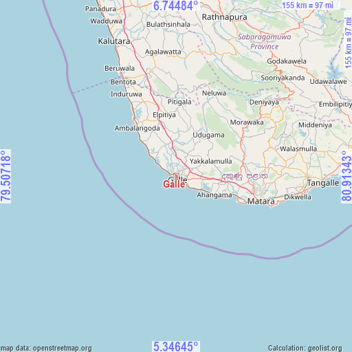
Galle GPS coordinates[2]
6° 2' 45.96" North, 80° 12' 37.08" East
| Map corner | latitude | longitude |
|---|---|---|
| Upper-left | 6.74484°, | 79.50718° |
| Center: | 6.0461°, | 80.2103° |
| Lower-right: | 5.34645°, | 80.91343° |
| Map W x H: | 155.5×155.5 km | = 96.6×96.6mi |
| max Lat: | 9.81667° ⇑89.5% North |
| Galle: | 6.0461° |
| min Lat: | ⇓10.5% South 5.92825° |
| min Long | Galle | max Long |
| 79.79528° | 80.2103° | 81.83472° |
| W 47.4%⇐ | ⇒52.6% E |
Elevation
Elevation of Galle is 4 m = 13 ft, and this is 153.4 m = 503 ft below average elevation for this country.
| Max E: |
1868 m = 6129 ft | 97.4% |
| Avg. | 157.4 m = 516 ft | |
| Galle | 4 m = 13 ft | |
Min E: |
1 m = 3 ft | 2.6% |
See also: Galle elevation on elevation.city.
Geographical zone
Galle is located in North Torrid zone (between Equator and Tropic of Cancer). Distance of Equator is 672.3 km =417.7 mi to South.| Distance of | km | miles | from Galle |
|---|---|---|---|
| North Pole | 9334.8 | 5800.4 | to North |
| Arctic Circle | 6728.9 | 4181.1 | to North |
| Tropic Cancer | 1933.7 | 1201.5 | to North |
| Equator | 672.3 | 417.7 | to South |


Nearby cities:
15 places around Galle: (largest is in red/bold)
• Ambalangoda
27.3 km =17 mi,  320°
320°
• Bentota
48.4 km =30.1 mi,  330°
330°
• Beruwala
54.3 km =33.7 mi, 332°
• Devinuwara
43.9 km =27.3 mi,  107°
107°
• Hikkaduwa
16 km =9.9 mi,  311°
311°
• Horawala Junction
49.2 km =30.6 mi,  349°
349°
• Kalutara
65.8 km =40.9 mi,  335°
335°
• Koggala
14.6 km =9.1 mi,  116°
116°
• Matara
37.5 km =23.3 mi, 106°
• Mirissa city
29.6 km =18.4 mi, 111°
• Ratnapura
74.3 km =46.2 mi,  16°
16°
• Talpe
9.1 km =5.7 mi, 124°
• Tangalle
65 km =40.4 mi,  92°
92°
• Unawatuna
5.2 km =3.2 mi, 122°
• Weligama
25.5 km =15.8 mi, 108°
Sources, notices
• [Note1] Compared only with cities in Sri Lanka existing in our database
• [Src1] Map data: © OpenStreetMap contributors (CC-BY-SA)
• [Src2] Other city data from geonames.org with taken over terms of usage.
• [Src3] Geographical zone / Annual Mean Temperature by Robert A. Rohde @ Wikipedia
