Teyateyaneng geodata
Teyateyaneng (Berea) is a seat of a first-order administrative division; located in Lesotho in Africa/Maseru (GMT+2) time zone. With population of 5,115 people, there are 11 cities with bigger population in this country. Compared to other cities in Lesotho, 72.7% of cities are located further ↓South; 63.6% of cities are located further →East and 54.5% of cities have lower elevation than Teyateyaneng. Note1


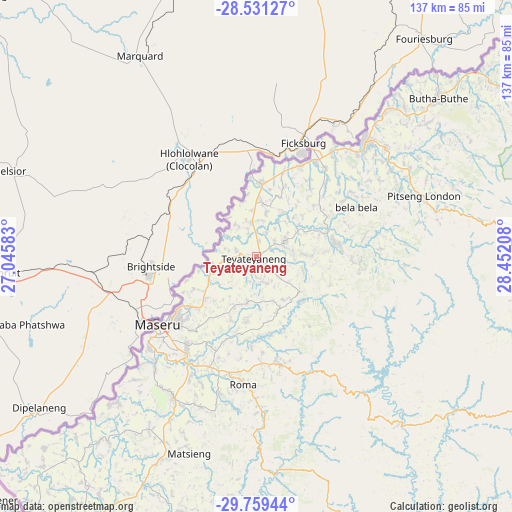
Teyateyaneng GPS coordinates[2]
29° 8' 49.884" South, 27° 44' 56.22" East
| Map corner | latitude | longitude |
|---|---|---|
| Upper-left | -28.53127°, | 27.04583° |
| Center: | -29.14719°, | 27.74895° |
| Lower-right: | -29.75944°, | 28.45208° |
| Map W x H: | 136.6×136.6 km | = 84.9×84.9mi |
| max Lat: | -28.76659° ⇑27.3% North |
| Teyateyaneng: | -29.14719° |
| min Lat: | ⇓72.7% South -30.40001° |
| min Long | Teyateyaneng | max Long |
| 27.23744° | 27.74895° | 29.06751° |
| W 36.4%⇐ | ⇒63.6% E |
Elevation
Elevation of Teyateyaneng is 1693 m = 5554 ft, and this is 73.2 m = 240 ft below average elevation for this country.
| Max E: |
2230 m = 7316 ft | 45.5% |
| Avg. | 1766.2 m = 5795 ft | |
| Teyateyaneng | 1693 m = 5554 ft | |
Min E: |
1515 m = 4970 ft | 54.5% |
See also: Lesotho elevation on elevation.city.
Geographical zone
Teyateyaneng is located in South temperate zone (between Tropic of Capricorn and the Antarctic Circle). Distance of this Southern Tropic circle is 634.9 km =394.5 mi to North.| Distance of | km | miles | from Teyateyaneng |
|---|---|---|---|
| Equator | 3240.9 | 2013.8 | to North |
| Tropic Capricorn | 634.9 | 394.5 | to North |
| Antarctic Circle | 4160.3 | 2585.1 | to South |
| South Pole | 6766.2 | 4204.3 | to South |


Nearby cities:
11 places around Teyateyaneng: (largest is in red/bold)
• Butha-Buthe
64.5 km =40.1 mi,  49°
49°
• Leribe
42 km =26.1 mi,  43°
43°
• Mafeteng
90 km =55.9 mi,  213°
213°
• Maputsoe
32.4 km =20.1 mi,  26°
26°
• Maseru
31.9 km =19.8 mi,  233°
233°
• Mohale’s Hoek
114.7 km =71.3 mi,  193°
193°
• Mokhotlong
128.9 km =80.1 mi,  97°
97°
• Nako
52.2 km =32.4 mi,  178°
178°
• Qacha’s Nek
140.9 km =87.6 mi,  139°
139°
• Quthing
139.4 km =86.6 mi, 181°
• Thaba-Tseka
93.2 km =57.9 mi,  116°
116°
Sources, notices
• [Note1] Compared only with cities in Lesotho existing in our database
• [Src1] Map data: © OpenStreetMap contributors (CC-BY-SA)
• [Src2] Other city data from geonames.org with taken over terms of usage.
• [Src3] Geographical zone / Annual Mean Temperature by Robert A. Rohde @ Wikipedia
