Quthing geodata
Quthing is a seat of a first-order administrative division; located in Lesotho in Africa/Maseru (GMT+2) time zone. With population of 24,130 people, there are 6 cities with bigger population in this country. Compared to other cities in Lesotho, 100% of cities are located further ↑North; 72.7% of cities are located further →East and 100% of cities have higher elevation than Quthing. Note1


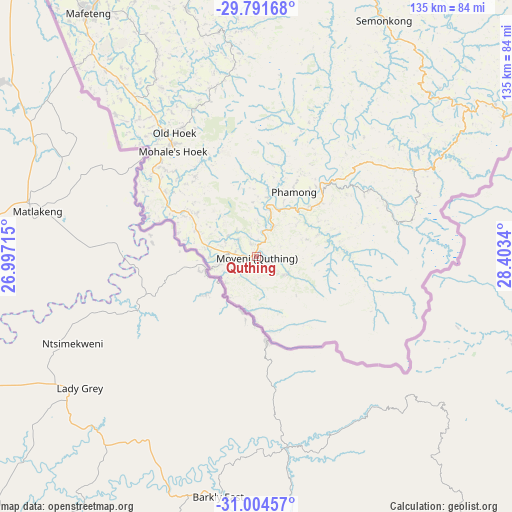
Quthing GPS coordinates[2]
30° 24' 0.036" South, 27° 42' 0.972" East
| Map corner | latitude | longitude |
|---|---|---|
| Upper-left | -29.79168°, | 26.99715° |
| Center: | -30.40001°, | 27.70027° |
| Lower-right: | -31.00457°, | 28.4034° |
| Map W x H: | 134.9×134.9 km | = 83.8×83.8mi |
| max Lat: | -28.76659° ⇑100% North |
| Quthing: | -30.40001° |
| min Lat: | ⇓0% South -30.40001° |
| min Long | Quthing | max Long |
| 27.23744° | 27.70027° | 29.06751° |
| W 27.3%⇐ | ⇒72.7% E |
Elevation
Elevation of Quthing is 1515 m = 4970 ft, and this is 251.2 m = 824 ft below average elevation for this country.
| Max E: |
2230 m = 7316 ft | 100% |
| Avg. | 1766.2 m = 5795 ft | |
| Quthing | 1515 m = 4970 ft | |
Min E: |
1515 m = 4970 ft | 0% |
See also: Lesotho elevation on elevation.city.
Geographical zone
Quthing is located in South temperate zone (between Tropic of Capricorn and the Antarctic Circle). Distance of this Southern Tropic circle is 774.2 km =481.1 mi to North.| Distance of | km | miles | from Quthing |
|---|---|---|---|
| Equator | 3380.2 | 2100.4 | to North |
| Tropic Capricorn | 774.2 | 481.1 | to North |
| Antarctic Circle | 4021 | 2498.5 | to South |
| South Pole | 6626.9 | 4117.8 | to South |


Nearby cities:
11 places around Quthing: (largest is in red/bold)
• Butha-Buthe
189.2 km =117.6 mi,  16°
16°
• Leribe
173.2 km =107.6 mi,  11°
11°
• Mafeteng
78.1 km =48.5 mi,  325°
325°
• Maputsoe
169.4 km =105.3 mi, 6°
• Maseru
122.3 km =76 mi,  350°
350°
• Mohale’s Hoek
35 km =21.7 mi,  322°
322°
• Mokhotlong
180.7 km =112.3 mi,  46°
46°
• Nako
87.3 km =54.2 mi,  4°
4°
• Qacha’s Nek
100.1 km =62.2 mi,  71°
71°
• Teyateyaneng
139.4 km =86.6 mi, 1°
• Thaba-Tseka
131.1 km =81.5 mi,  41°
41°
Sources, notices
• [Note1] Compared only with cities in Lesotho existing in our database
• [Src1] Map data: © OpenStreetMap contributors (CC-BY-SA)
• [Src2] Other city data from geonames.org with taken over terms of usage.
• [Src3] Geographical zone / Annual Mean Temperature by Robert A. Rohde @ Wikipedia
