Maputsoe geodata
Maputsoe (Leribe) is a populated place; located in Lesotho in Africa/Maseru (GMT+2) time zone. With population of 32,117 people, there are 3 cities with bigger population in this country. Compared to other cities in Lesotho, 81.8% of cities are located further ↓South; 54.5% of cities are located further ←West and 81.8% of cities have higher elevation than Maputsoe. Note1


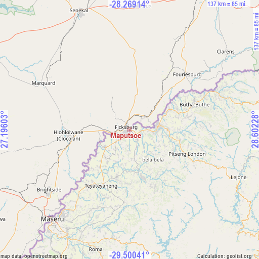
Maputsoe GPS coordinates[2]
28° 53' 11.76" South, 27° 53' 56.94" East
| Map corner | latitude | longitude |
|---|---|---|
| Upper-left | -28.26914°, | 27.19603° |
| Center: | -28.8866°, | 27.89915° |
| Lower-right: | -29.50041°, | 28.60228° |
| Map W x H: | 136.9×136.9 km | = 85.1×85.1mi |
| max Lat: | -28.76659° ⇑18.2% North |
| Maputsoe: | -28.8866° |
| min Lat: | ⇓81.8% South -30.40001° |
| min Long | Maputsoe | max Long |
| 27.23744° | 27.89915° | 29.06751° |
| W 54.5%⇐ | ⇒45.5% E |
Elevation
Elevation of Maputsoe is 1583 m = 5194 ft, and this is 183.2 m = 601 ft below average elevation for this country.
| Max E: |
2230 m = 7316 ft | 81.8% |
| Avg. | 1766.2 m = 5795 ft | |
| Maputsoe | 1583 m = 5194 ft | |
Min E: |
1515 m = 4970 ft | 18.2% |
See also: Lesotho elevation on elevation.city.
Geographical zone
Maputsoe is located in South temperate zone (between Tropic of Capricorn and the Antarctic Circle). Distance of this Southern Tropic circle is 606 km =376.6 mi to North.| Distance of | km | miles | from Maputsoe |
|---|---|---|---|
| Equator | 3211.9 | 1995.8 | to North |
| Tropic Capricorn | 606 | 376.6 | to North |
| Antarctic Circle | 4189.3 | 2603.1 | to South |
| South Pole | 6795.2 | 4222.3 | to South |


Nearby cities:
11 places around Maputsoe: (largest is in red/bold)
• Butha-Buthe
36.6 km =22.7 mi,  68°
68°
• Leribe
14.3 km =8.9 mi,  83°
83°
• Mafeteng
122.3 km =76 mi,  211°
211°
• Maseru
62.6 km =38.9 mi,  220°
220°
• Mohale’s Hoek
146.4 km =91 mi,  196°
196°
• Mokhotlong
122 km =75.8 mi,  111°
111°
• Nako
82.2 km =51.1 mi,  188°
188°
• Qacha’s Nek
156.6 km =97.3 mi,  150°
150°
• Quthing
169.4 km =105.3 mi, 186°
• Teyateyaneng
32.4 km =20.1 mi, 206°
• Thaba-Tseka
98.6 km =61.3 mi,  135°
135°
Sources, notices
• [Note1] Compared only with cities in Lesotho existing in our database
• [Src1] Map data: © OpenStreetMap contributors (CC-BY-SA)
• [Src2] Other city data from geonames.org with taken over terms of usage.
• [Src3] Geographical zone / Annual Mean Temperature by Robert A. Rohde @ Wikipedia
