Qacha’s Nek geodata
Qacha’s Nek (Qachaʼs Nek) is a seat of a first-order administrative division; located in Lesotho in Africa/Maseru (GMT+2) time zone. With population of 25,573 people, there are 5 cities with bigger population in this country. Compared to other cities in Lesotho, 81.8% of cities are located further ↑North; 90.9% of cities are located further ←West and 81.8% of cities have lower elevation than Qacha’s Nek. Note1


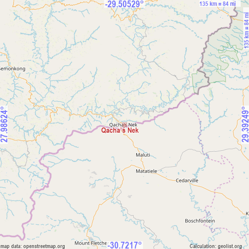
Qacha’s Nek GPS coordinates[2]
30° 6' 55.332" South, 28° 41' 21.696" East
| Map corner | latitude | longitude |
|---|---|---|
| Upper-left | -29.50529°, | 27.98624° |
| Center: | -30.11537°, | 28.68936° |
| Lower-right: | -30.7217°, | 29.39249° |
| Map W x H: | 135.3×135.3 km | = 84.1×84.1mi |
| max Lat: | -28.76659° ⇑81.8% North |
| Qacha’s Nek: | -30.11537° |
| min Lat: | ⇓18.2% South -30.40001° |
| min Long | Qacha’s Nek | max Long |
| 27.23744° | 28.68936° | 29.06751° |
| W 90.9%⇐ | ⇒9.1% E |
Elevation
Elevation of Qacha’s Nek is 1974 m = 6476 ft, and this is 207.8 m = 682 ft above average elevation for this country.
| Max E: |
2230 m = 7316 ft | 18.2% |
| Qacha’s Nek | 1974 m 6476 ft | |
| Avg. | 1766.2 m = 5795 ft | |
Min E: |
1515 m = 4970 ft | 81.8% |
See also: Lesotho elevation on elevation.city.
Geographical zone
Qacha’s Nek is located in South temperate zone (between Tropic of Capricorn and the Antarctic Circle). Distance of this Southern Tropic circle is 742.6 km =461.4 mi to North.| Distance of | km | miles | from Qacha’s Nek |
|---|---|---|---|
| Equator | 3348.5 | 2080.7 | to North |
| Tropic Capricorn | 742.6 | 461.4 | to North |
| Antarctic Circle | 4052.7 | 2518.2 | to South |
| South Pole | 6658.5 | 4137.4 | to South |


Nearby cities:
11 places around Qacha’s Nek: (largest is in red/bold)
• Butha-Buthe
155.9 km =96.9 mi,  344°
344°
• Leribe
151.7 km =94.3 mi, 335°
• Mafeteng
143.6 km =89.2 mi,  283°
283°
• Maputsoe
156.6 km =97.3 mi,  330°
330°
• Maseru
146.5 km =91 mi,  307°
307°
• Mohale’s Hoek
116.7 km =72.5 mi,  268°
268°
• Mokhotlong
98.8 km =61.4 mi,  21°
21°
• Nako
104.8 km =65.1 mi,  301°
301°
• Quthing
100.1 km =62.2 mi,  251°
251°
• Teyateyaneng
140.9 km =87.6 mi,  319°
319°
• Thaba-Tseka
66.4 km =41.3 mi,  353°
353°
Sources, notices
• [Note1] Compared only with cities in Lesotho existing in our database
• [Src1] Map data: © OpenStreetMap contributors (CC-BY-SA)
• [Src2] Other city data from geonames.org with taken over terms of usage.
• [Src3] Geographical zone / Annual Mean Temperature by Robert A. Rohde @ Wikipedia
