Mohale’s Hoek geodata
Mohale’s Hoek (Mohaleʼs Hoek) is a seat of a first-order administrative division; located in Lesotho in Africa/Maseru (GMT+2) time zone. With population of 28,310 people, there are 4 cities with bigger population in this country. Compared to other cities in Lesotho, 90.9% of cities are located further ↑North; 90.9% of cities are located further →East and 72.7% of cities have higher elevation than Mohale’s Hoek. Note1


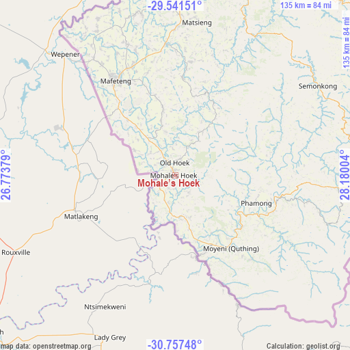
Mohale’s Hoek GPS coordinates[2]
30° 9' 4.932" South, 27° 28' 36.876" East
| Map corner | latitude | longitude |
|---|---|---|
| Upper-left | -29.54151°, | 26.77379° |
| Center: | -30.15137°, | 27.47691° |
| Lower-right: | -30.75748°, | 28.18004° |
| Map W x H: | 135.2×135.2 km | = 84×84mi |
| max Lat: | -28.76659° ⇑90.9% North |
| Mohale’s Hoek: | -30.15137° |
| min Lat: | ⇓9.1% South -30.40001° |
| min Long | Mohale’s Hoek | max Long |
| 27.23744° | 27.47691° | 29.06751° |
| W 9.1%⇐ | ⇒90.9% E |
Elevation
Elevation of Mohale’s Hoek is 1598 m = 5243 ft, and this is 168.2 m = 552 ft below average elevation for this country.
| Max E: |
2230 m = 7316 ft | 72.7% |
| Avg. | 1766.2 m = 5795 ft | |
| Mohale’s Hoek | 1598 m = 5243 ft | |
Min E: |
1515 m = 4970 ft | 27.3% |
See also: Lesotho elevation on elevation.city.
Geographical zone
Mohale’s Hoek is located in South temperate zone (between Tropic of Capricorn and the Antarctic Circle). Distance of this Southern Tropic circle is 746.6 km =463.9 mi to North.| Distance of | km | miles | from Mohale’s Hoek |
|---|---|---|---|
| Equator | 3352.5 | 2083.1 | to North |
| Tropic Capricorn | 746.6 | 463.9 | to North |
| Antarctic Circle | 4048.7 | 2515.7 | to South |
| South Pole | 6654.5 | 4134.9 | to South |


Nearby cities:
11 places around Mohale’s Hoek: (largest is in red/bold)
• Butha-Buthe
171.2 km =106.4 mi,  25°
25°
• Leribe
152.5 km =94.8 mi,  21°
21°
• Mafeteng
43.2 km =26.8 mi,  327°
327°
• Maputsoe
146.4 km =91 mi, 16°
• Maseru
92.8 km =57.7 mi,  0°
0°
• Mokhotlong
181 km =112.5 mi,  58°
58°
• Nako
65.7 km =40.8 mi, 25°
• Qacha’s Nek
116.7 km =72.5 mi,  88°
88°
• Quthing
35 km =21.7 mi,  142°
142°
• Teyateyaneng
114.7 km =71.3 mi,  13°
13°
• Thaba-Tseka
129.6 km =80.5 mi, 57°
Sources, notices
• [Note1] Compared only with cities in Lesotho existing in our database
• [Src1] Map data: © OpenStreetMap contributors (CC-BY-SA)
• [Src2] Other city data from geonames.org with taken over terms of usage.
• [Src3] Geographical zone / Annual Mean Temperature by Robert A. Rohde @ Wikipedia
