Mokhotlong geodata
Mokhotlong is a seat of a first-order administrative division; located in Lesotho in Africa/Maseru (GMT+2) time zone. With population of 8,809 people, there are 9 cities with bigger population in this country. Compared to other cities in Lesotho, 63.6% of cities are located further ↓South; 100% of cities are located further ←West and 90.9% of cities have lower elevation than Mokhotlong. Note1


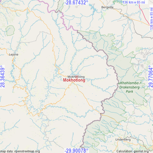
Mokhotlong GPS coordinates[2]
29° 17' 21.804" South, 29° 4' 3.036" East
| Map corner | latitude | longitude |
|---|---|---|
| Upper-left | -28.67432°, | 28.36439° |
| Center: | -29.28939°, | 29.06751° |
| Lower-right: | -29.90078°, | 29.77064° |
| Map W x H: | 136.4×136.4 km | = 84.8×84.8mi |
| max Lat: | -28.76659° ⇑36.4% North |
| Mokhotlong: | -29.28939° |
| min Lat: | ⇓63.6% South -30.40001° |
| min Long | Mokhotlong | max Long |
| 27.23744° | 29.06751° | 29.06751° |
| W 100%⇐ | ⇒0% E |
Elevation
Elevation of Mokhotlong is 2201 m = 7221 ft, and this is 434.8 m = 1427 ft above average elevation for this country.
| Max E: |
2230 m = 7316 ft | 9.1% |
| Mokhotlong | 2201 m 7221 ft | |
| Avg. | 1766.2 m = 5795 ft | |
Min E: |
1515 m = 4970 ft | 90.9% |
See also: Lesotho elevation on elevation.city.
Geographical zone
Mokhotlong is located in South temperate zone (between Tropic of Capricorn and the Antarctic Circle). Distance of this Southern Tropic circle is 650.8 km =404.4 mi to North.| Distance of | km | miles | from Mokhotlong |
|---|---|---|---|
| Equator | 3256.7 | 2023.6 | to North |
| Tropic Capricorn | 650.8 | 404.4 | to North |
| Antarctic Circle | 4144.5 | 2575.3 | to South |
| South Pole | 6750.4 | 4194.5 | to South |


Nearby cities:
11 places around Mokhotlong: (largest is in red/bold)
• Butha-Buthe
98.5 km =61.2 mi,  306°
306°
• Leribe
109.7 km =68.2 mi,  295°
295°
• Mafeteng
186.7 km =116 mi,  251°
251°
• Maputsoe
122 km =75.8 mi,  291°
291°
• Maseru
153.6 km =95.4 mi,  268°
268°
• Mohale’s Hoek
181 km =112.5 mi,  238°
238°
• Nako
131.1 km =81.5 mi, 253°
• Qacha’s Nek
98.8 km =61.4 mi,  201°
201°
• Quthing
180.7 km =112.3 mi,  226°
226°
• Teyateyaneng
128.9 km =80.1 mi,  277°
277°
• Thaba-Tseka
51.4 km =31.9 mi, 239°
Sources, notices
• [Note1] Compared only with cities in Lesotho existing in our database
• [Src1] Map data: © OpenStreetMap contributors (CC-BY-SA)
• [Src2] Other city data from geonames.org with taken over terms of usage.
• [Src3] Geographical zone / Annual Mean Temperature by Robert A. Rohde @ Wikipedia
