Skuodas geodata
Skuodas (Klaipėda County) is a seat of a second-order administrative division; located in Lithuania in Europe/Vilnius (GMT+3) time zone. With population of 7,726 people, there are 55 cities with bigger population in this country. Compared to other cities in Lithuania, 97.8% of cities are located further ↓South; 91.8% of cities are located further →East and 91.8% of cities have higher elevation than Skuodas. Note1


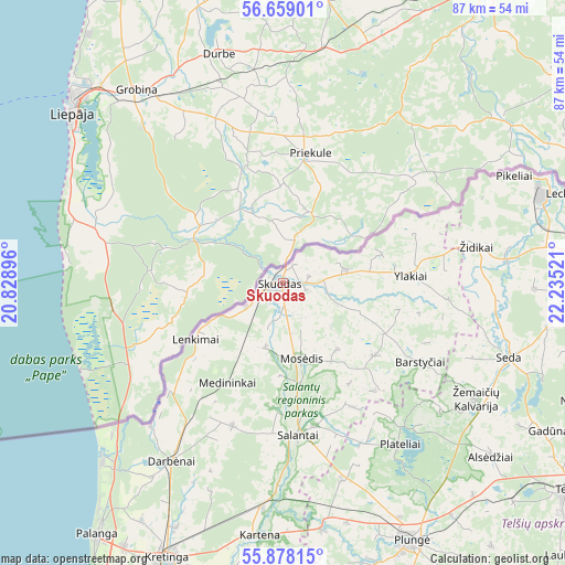
Skuodas GPS coordinates[2]
56° 16' 14.052" North, 21° 31' 55.488" East
| Map corner | latitude | longitude |
|---|---|---|
| Upper-left | 56.65901°, | 20.82896° |
| Center: | 56.27057°, | 21.53208° |
| Lower-right: | 55.87815°, | 22.23521° |
| Map W x H: | 86.8×86.8 km | = 53.9×53.9mi |
| max Lat: | 56.36149° ⇑2.2% North |
| Skuodas: | 56.27057° |
| min Lat: | ⇓97.8% South 54.01573° |
| min Long | Skuodas | max Long |
| 20.99651° | 21.53208° | 26.43984° |
| W 8.2%⇐ | ⇒91.8% E |
Elevation
Elevation of Skuodas is 25 m = 82 ft, and this is 65.7 m = 216 ft below average elevation for this country.
| Max E: |
204 m = 669 ft | 91.8% |
| Avg. | 90.7 m = 298 ft | |
| Skuodas | 25 m = 82 ft | |
Min E: |
-1 m = -3 ft | 8.2% |
See also: Lithuania elevation on elevation.city.
Geographical zone
Skuodas is located in North temperate zone (between Tropic of Cancer and the Arctic Circle). Distance of this North polar circle is 1144.5 km =711.2 mi to North.| Distance of | km | miles | from Skuodas |
|---|---|---|---|
| North Pole | 3750.4 | 2330.4 | to North |
| Arctic Circle | 1144.5 | 711.2 | to North |
| Tropic Cancer | 3650.8 | 2268.5 | to South |
| Equator | 6256.7 | 3887.7 | to South |


Nearby cities:
15 places around Skuodas: (largest is in red/bold)
• Akmenė
75.2 km =46.7 mi,  91°
91°
• Gargždai
63 km =39.1 mi,  187°
187°
• Klaipėda
67.3 km =41.8 mi,  201°
201°
• Kretinga
46 km =28.6 mi, 202°
• Mazeikiai
49.7 km =30.9 mi,  84°
84°
• Palanga
48.7 km =30.3 mi,  216°
216°
• Plateliai
30.5 km =19 mi,  144°
144°
• Plunge
44.4 km =27.6 mi,  154°
154°
• Rietavas
65.1 km =40.5 mi,  158°
158°
• Salantai
23.9 km =14.9 mi,  174°
174°
• Seda
36.4 km =22.6 mi,  108°
108°
• Telsiai
54.8 km =34.1 mi,  125°
125°
• Venta
72.4 km =45 mi,  96°
96°
• Viekšniai
60.9 km =37.8 mi, 93°
• Šventoji
38.8 km =24.1 mi,  225°
225°
Sources, notices
• [Note1] Compared only with cities in Lithuania existing in our database
• [Src1] Map data: © OpenStreetMap contributors (CC-BY-SA)
• [Src2] Other city data from geonames.org with taken over terms of usage.
• [Src3] Geographical zone / Annual Mean Temperature by Robert A. Rohde @ Wikipedia
