Telsiai geodata
Telsiai is a seat of a first-order administrative division; located in Lithuania in Europe/Vilnius (GMT+3) time zone. With population of 30,098 people, there are 18 cities with bigger population in this country. Compared to other cities in Lithuania, 85.8% of cities are located further ↓South; 85.1% of cities are located further →East and 80.6% of cities have lower elevation than Telsiai. Note1


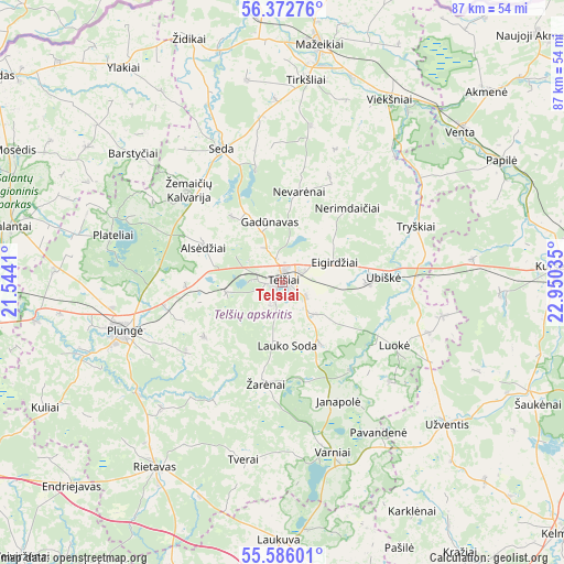
Telsiai GPS coordinates[2]
55° 58' 53.004" North, 22° 14' 49.992" East
| Map corner | latitude | longitude |
|---|---|---|
| Upper-left | 56.37276°, | 21.5441° |
| Center: | 55.98139°, | 22.24722° |
| Lower-right: | 55.58601°, | 22.95035° |
| Map W x H: | 87.5×87.5 km | = 54.4×54.4mi |
| max Lat: | 56.36149° ⇑14.2% North |
| Telsiai: | 55.98139° |
| min Lat: | ⇓85.8% South 54.01573° |
| min Long | Telsiai | max Long |
| 20.99651° | 22.24722° | 26.43984° |
| W 14.9%⇐ | ⇒85.1% E |
Elevation
Elevation of Telsiai is 135 m = 443 ft, and this is 44.3 m = 145 ft above average elevation for this country.
| Max E: |
204 m = 669 ft | 19.4% |
| Telsiai | 135 m 443 ft | |
| Avg. | 90.7 m = 298 ft | |
Min E: |
-1 m = -3 ft | 80.6% |
See also: Lithuania elevation on elevation.city.
Geographical zone
Telsiai is located in North temperate zone (between Tropic of Cancer and the Arctic Circle). Distance of this North polar circle is 1176.6 km =731.1 mi to North.| Distance of | km | miles | from Telsiai |
|---|---|---|---|
| North Pole | 3782.5 | 2350.3 | to North |
| Arctic Circle | 1176.6 | 731.1 | to North |
| Tropic Cancer | 3618.6 | 2248.5 | to South |
| Equator | 6224.5 | 3867.7 | to South |


Nearby cities:
15 places around Telsiai: (largest is in red/bold)
• Akmenė
43.2 km =26.8 mi,  46°
46°
• Kuršėnai
42.9 km =26.7 mi,  86°
86°
• Mazeikiai
37.7 km =23.4 mi,  8°
8°
• Naujoji Akmene
55 km =34.2 mi, 47°
• Plateliai
27.8 km =17.3 mi,  285°
285°
• Plunge
26.3 km =16.3 mi,  252°
252°
• Rietavas
34.8 km =21.6 mi,  215°
215°
• Salantai
43 km =26.7 mi,  281°
281°
• Seda
23 km =14.3 mi,  334°
334°
• Skuodas
54.8 km =34.1 mi,  305°
305°
• Užventis
33.5 km =20.8 mi,  131°
131°
• Varniai
27.5 km =17.1 mi,  163°
163°
• Venta
36.3 km =22.6 mi, 49°
• Viekšniai
32.9 km =20.4 mi,  30°
30°
• Šilalė
54.8 km =34.1 mi,  183°
183°
In other languages:
- In Spanish: Telšiai
- In France: Telšiai
- In German: Telšiai, Telschen
- In Russian: Тельшяй
- In Chinese: 特爾希艾
Sources, notices
• [Note1] Compared only with cities in Lithuania existing in our database
• [Src1] Map data: © OpenStreetMap contributors (CC-BY-SA)
• [Src2] Other city data from geonames.org with taken over terms of usage.
• [Src3] Geographical zone / Annual Mean Temperature by Robert A. Rohde @ Wikipedia
