Seda geodata
Seda (Telsiai) is a populated place; located in Lithuania in Europe/Vilnius (GMT+3) time zone. With population of 1,224 people, there are 116 cities with bigger population in this country. Compared to other cities in Lithuania, 93.3% of cities are located further ↓South; 86.6% of cities are located further →East and 68.7% of cities have lower elevation than Seda. Note1


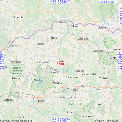
Seda GPS coordinates[2]
56° 10' 6.744" North, 22° 5' 26.556" East
| Map corner | latitude | longitude |
|---|---|---|
| Upper-left | 56.55801°, | 21.38759° |
| Center: | 56.16854°, | 22.09071° |
| Lower-right: | 55.77507°, | 22.79384° |
| Map W x H: | 87.1×87.1 km | = 54.1×54.1mi |
| max Lat: | 56.36149° ⇑6.7% North |
| Seda: | 56.16854° |
| min Lat: | ⇓93.3% South 54.01573° |
| min Long | Seda | max Long |
| 20.99651° | 22.09071° | 26.43984° |
| W 13.4%⇐ | ⇒86.6% E |
Elevation
Elevation of Seda is 115 m = 377 ft, and this is 24.3 m = 80 ft above average elevation for this country.
| Max E: |
204 m = 669 ft | 31.3% |
| Seda | 115 m 377 ft | |
| Avg. | 90.7 m = 298 ft | |
Min E: |
-1 m = -3 ft | 68.7% |
See also: Lithuania elevation on elevation.city.
Geographical zone
Seda is located in North temperate zone (between Tropic of Cancer and the Arctic Circle). Distance of this North polar circle is 1155.8 km =718.2 mi to North.| Distance of | km | miles | from Seda |
|---|---|---|---|
| North Pole | 3761.7 | 2337.4 | to North |
| Arctic Circle | 1155.8 | 718.2 | to North |
| Tropic Cancer | 3639.4 | 2261.4 | to South |
| Equator | 6245.4 | 3880.7 | to South |


Nearby cities:
15 places around Seda: (largest is in red/bold)
• Akmenė
41.8 km =26 mi,  77°
77°
• Kretinga
61.1 km =38 mi,  239°
239°
• Kuršėnai
55.6 km =34.5 mi,  109°
109°
• Mazeikiai
22.3 km =13.9 mi,  42°
42°
• Naujoji Akmene
52.6 km =32.7 mi,  71°
71°
• Plateliai
21.8 km =13.5 mi,  231°
231°
• Plunge
32.4 km =20.1 mi,  208°
208°
• Rietavas
50.2 km =31.2 mi,  191°
191°
• Salantai
34.7 km =21.6 mi,  248°
248°
• Skuodas
36.4 km =22.6 mi,  288°
288°
• Telsiai
23 km =14.3 mi,  154°
154°
• Užventis
55.3 km =34.4 mi,  140°
140°
• Varniai
50.3 km =31.3 mi,  159°
159°
• Venta
37.5 km =23.3 mi,  86°
86°
• Viekšniai
27.4 km =17 mi, 74°
Sources, notices
• [Note1] Compared only with cities in Lithuania existing in our database
• [Src1] Map data: © OpenStreetMap contributors (CC-BY-SA)
• [Src2] Other city data from geonames.org with taken over terms of usage.
• [Src3] Geographical zone / Annual Mean Temperature by Robert A. Rohde @ Wikipedia
