Utena geodata
Utena is a seat of a first-order administrative division; located in Lithuania in Europe/Vilnius (GMT+3) time zone. With population of 33,240 people, there are 13 cities with bigger population in this country. Compared to other cities in Lithuania, 64.9% of cities are located further ↓South; 92.5% of cities are located further ←West and 61.2% of cities have lower elevation than Utena. Note1


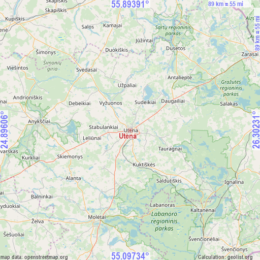
Utena GPS coordinates[2]
55° 29' 51.504" North, 25° 35' 57.048" East
| Map corner | latitude | longitude |
|---|---|---|
| Upper-left | 55.89391°, | 24.89606° |
| Center: | 55.49764°, | 25.59918° |
| Lower-right: | 55.09734°, | 26.30231° |
| Map W x H: | 88.6×88.6 km | = 55.1×55.1mi |
| max Lat: | 56.36149° ⇑35.1% North |
| Utena: | 55.49764° |
| min Lat: | ⇓64.9% South 54.01573° |
| min Long | Utena | max Long |
| 20.99651° | 25.59918° | 26.43984° |
| W 92.5%⇐ | ⇒7.5% E |
Elevation
Elevation of Utena is 104 m = 341 ft, and this is 13.3 m = 44 ft above average elevation for this country.
| Max E: |
204 m = 669 ft | 38.8% |
| Utena | 104 m 341 ft | |
| Avg. | 90.7 m = 298 ft | |
Min E: |
-1 m = -3 ft | 61.2% |
See also: Lithuania elevation on elevation.city.
Geographical zone
Utena is located in North temperate zone (between Tropic of Cancer and the Arctic Circle). Distance of this North polar circle is 1230.4 km =764.5 mi to North.| Distance of | km | miles | from Utena |
|---|---|---|---|
| North Pole | 3836.3 | 2383.8 | to North |
| Arctic Circle | 1230.4 | 764.5 | to North |
| Tropic Cancer | 3564.8 | 2215.1 | to South |
| Equator | 6170.8 | 3834.4 | to South |


Nearby cities:
15 places around Utena: (largest is in red/bold)
• Anyksciai
31.4 km =19.5 mi,  275°
275°
• Dusetos
31.7 km =19.7 mi,  29°
29°
• Dūkštas
45.5 km =28.3 mi,  86°
86°
• Ignalina
39.5 km =24.5 mi,  116°
116°
• Kavarskas
42.9 km =26.7 mi,  260°
260°
• Kupiskis
54.4 km =33.8 mi,  314°
314°
• Molėtai
32.5 km =20.2 mi,  200°
200°
• Obeliai
59.3 km =36.8 mi,  332°
332°
• Pabradė
58.4 km =36.3 mi,  169°
169°
• Rokiškis
51.3 km =31.9 mi,  359°
359°
• Ukmerge
60.3 km =37.5 mi,  242°
242°
• Visaginas
54 km =33.6 mi,  78°
78°
• Zarasai
48.5 km =30.1 mi,  57°
57°
• Švenčionys
53.7 km =33.4 mi,  138°
138°
• Švenčionėliai
45.2 km =28.1 mi,  145°
145°
Sources, notices
• [Note1] Compared only with cities in Lithuania existing in our database
• [Src1] Map data: © OpenStreetMap contributors (CC-BY-SA)
• [Src2] Other city data from geonames.org with taken over terms of usage.
• [Src3] Geographical zone / Annual Mean Temperature by Robert A. Rohde @ Wikipedia
