Kavarskas geodata
Kavarskas (Utena) is a populated place; located in Lithuania in Europe/Vilnius (GMT+3) time zone. With population of 755 people, there are 130 cities with bigger population in this country. Compared to other cities in Lithuania, 63.4% of cities are located further ↓South; 72.4% of cities are located further ←West and 68.7% of cities have higher elevation than Kavarskas. Note1


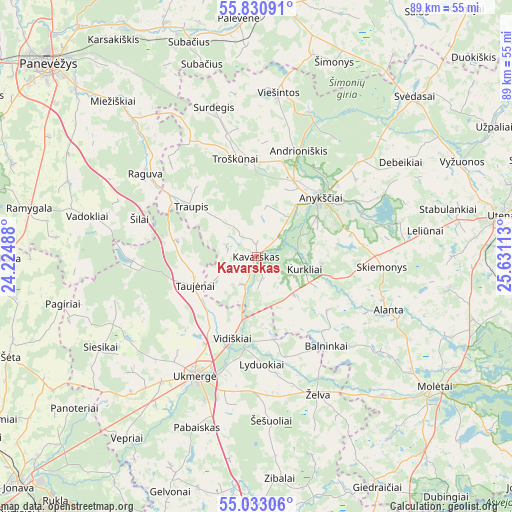
Kavarskas GPS coordinates[2]
55° 26' 2.4" North, 24° 55' 40.8" East
| Map corner | latitude | longitude |
|---|---|---|
| Upper-left | 55.83091°, | 24.22488° |
| Center: | 55.434°, | 24.928° |
| Lower-right: | 55.03306°, | 25.63113° |
| Map W x H: | 88.7×88.7 km | = 55.1×55.1mi |
| max Lat: | 56.36149° ⇑36.6% North |
| Kavarskas: | 55.434° |
| min Lat: | ⇓63.4% South 54.01573° |
| min Long | Kavarskas | max Long |
| 20.99651° | 24.928° | 26.43984° |
| W 72.4%⇐ | ⇒27.6% E |
Elevation
Elevation of Kavarskas is 67 m = 220 ft, and this is 23.7 m = 78 ft below average elevation for this country.
| Max E: |
204 m = 669 ft | 68.7% |
| Avg. | 90.7 m = 298 ft | |
| Kavarskas | 67 m = 220 ft | |
Min E: |
-1 m = -3 ft | 31.3% |
See also: Lithuania elevation on elevation.city.
Geographical zone
Kavarskas is located in North temperate zone (between Tropic of Cancer and the Arctic Circle). Distance of this North polar circle is 1237.5 km =768.9 mi to North.| Distance of | km | miles | from Kavarskas |
|---|---|---|---|
| North Pole | 3843.4 | 2388.2 | to North |
| Arctic Circle | 1237.5 | 768.9 | to North |
| Tropic Cancer | 3557.8 | 2210.7 | to South |
| Equator | 6163.7 | 3829.9 | to South |


Nearby cities:
15 places around Kavarskas: (largest is in red/bold)
• Anyksciai
15 km =9.3 mi,  47°
47°
• Dotnuva
66.3 km =41.2 mi,  263°
263°
• Jonava
56.5 km =35.1 mi,  226°
226°
• Kupiskis
45.3 km =28.1 mi,  4°
4°
• Kėdainiai
62.5 km =38.8 mi,  254°
254°
• Molėtai
38.7 km =24 mi,  126°
126°
• Naujamiestis
56.2 km =34.9 mi,  300°
300°
• Obeliai
61.2 km =38 mi,  13°
13°
• Panevėžys
49.3 km =30.6 mi,  312°
312°
• Ramygala
40.6 km =25.2 mi,  282°
282°
• Ukmerge
23.4 km =14.5 mi,  208°
208°
• Utena
42.9 km =26.7 mi,  80°
80°
• Vabalninkas
61.9 km =38.5 mi,  349°
349°
• Vepriai
38.7 km =24 mi,  215°
215°
• Širvintos
43.4 km =27 mi,  177°
177°
Sources, notices
• [Note1] Compared only with cities in Lithuania existing in our database
• [Src1] Map data: © OpenStreetMap contributors (CC-BY-SA)
• [Src2] Other city data from geonames.org with taken over terms of usage.
• [Src3] Geographical zone / Annual Mean Temperature by Robert A. Rohde @ Wikipedia
