Weiswampach geodata
Weiswampach (Clervaux) is a seat of a third-order administrative division; located in Luxembourg in Europe/Luxembourg (GMT+2) time zone. With population of 691 people, there are 112 cities with bigger population in this country. Compared to other cities in Luxembourg, 100% of cities are located further ↓South; 57.1% of cities are located further →East and 98.9% of cities have lower elevation than Weiswampach. Note1


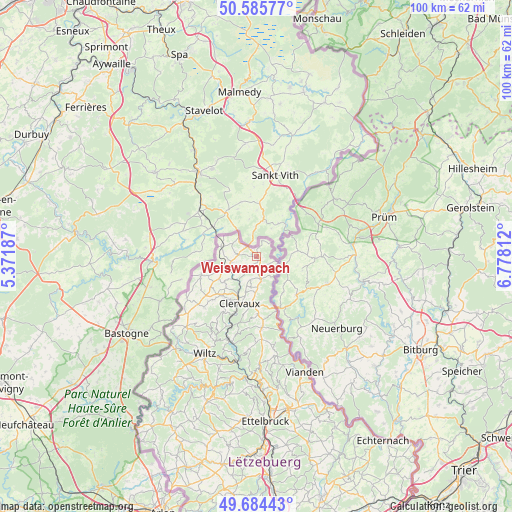
Weiswampach GPS coordinates[2]
50° 8' 13.992" North, 6° 4' 30" East
| Map corner | latitude | longitude |
|---|---|---|
| Upper-left | 50.58577°, | 5.37187° |
| Center: | 50.13722°, | 6.075° |
| Lower-right: | 49.68443°, | 6.77812° |
| Map W x H: | 100.2×100.2 km | = 62.3×62.3mi |
| max Lat: | 50.13722° ⇑0% North |
| Weiswampach: | 50.13722° |
| min Lat: | ⇓100% South 49.45964° |
| min Long | Weiswampach | max Long |
| 5.76583° | 6.075° | 6.50532° |
| W 42.9%⇐ | ⇒57.1% E |
Elevation
Elevation of Weiswampach is 492 m = 1614 ft, and this is 210 m = 689 ft above average elevation for this country.
| Max E: |
502 m = 1647 ft | 1.1% |
| Weiswampach | 492 m 1614 ft | |
| Avg. | 282 m = 925 ft | |
Min E: |
143 m = 469 ft | 98.9% |
See also: Luxembourg elevation on elevation.city.
Geographical zone
Weiswampach is located in North temperate zone (between Tropic of Cancer and the Arctic Circle). Distance of this North polar circle is 1826.4 km =1134.9 mi to North.| Distance of | km | miles | from Weiswampach |
|---|---|---|---|
| North Pole | 4432.3 | 2754.1 | to North |
| Arctic Circle | 1826.4 | 1134.9 | to North |
| Tropic Cancer | 2968.8 | 1844.7 | to South |
| Equator | 5574.7 | 3464 | to South |


Nearby cities:
15 places around Weiswampach: (largest is in red/bold)
• Bavigne
28.9 km =18 mi,  213°
213°
• Bourscheid
25.4 km =15.8 mi,  181°
181°
• Clervaux
9.7 km =6 mi,  198°
198°
• Erpeldange
30.4 km =18.9 mi,  174°
174°
• Esch-sur-Sûre
27 km =16.8 mi, 201°
• Goesdorf
25.2 km =15.7 mi, 197°
• Hosingen
13.9 km =8.6 mi, 175°
• Putscheid
20.2 km =12.6 mi, 166°
• Tandel
27.8 km =17.3 mi,  163°
163°
• Troisvierges
5.6 km =3.5 mi,  251°
251°
• Vianden
24.4 km =15.2 mi, 156°
• Wiltz
21.6 km =13.4 mi, 207°
• Wilwerwiltz
17.4 km =10.8 mi, 198°
• Wincrange
14.5 km =9 mi,  229°
229°
• Winseler
23 km =14.3 mi, 214°
Sources, notices
• [Note1] Compared only with cities in Luxembourg existing in our database
• [Src1] Map data: © OpenStreetMap contributors (CC-BY-SA)
• [Src2] Other city data from geonames.org with taken over terms of usage.
• [Src3] Geographical zone / Annual Mean Temperature by Robert A. Rohde @ Wikipedia
