Mamer geodata
Mamer (Capellen) is a seat of a third-order administrative division; located in Luxembourg in Europe/Luxembourg (GMT+2) time zone. With population of 5,017 people, there are 12 cities with bigger population in this country. Compared to other cities in Luxembourg, 59.3% of cities are located further ↑North; 67.2% of cities are located further →East and 56.5% of cities have lower elevation than Mamer. Note1


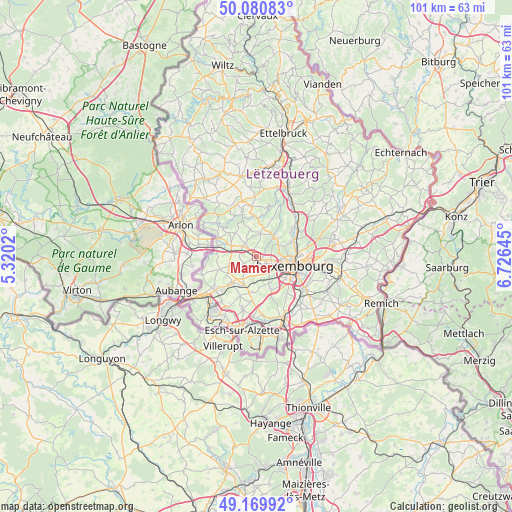
Mamer GPS coordinates[2]
49° 37' 39" North, 6° 1' 23.988" East
| Map corner | latitude | longitude |
|---|---|---|
| Upper-left | 50.08083°, | 5.3202° |
| Center: | 49.6275°, | 6.02333° |
| Lower-right: | 49.16992°, | 6.72645° |
| Map W x H: | 101.3×101.3 km | = 62.9×62.9mi |
| max Lat: | 50.13722° ⇑59.3% North |
| Mamer: | 49.6275° |
| min Lat: | ⇓40.7% South 49.45964° |
| min Long | Mamer | max Long |
| 5.76583° | 6.02333° | 6.50532° |
| W 32.8%⇐ | ⇒67.2% E |
Elevation
Elevation of Mamer is 294 m = 965 ft, and this is 12 m = 39 ft above average elevation for this country.
| Max E: |
502 m = 1647 ft | 43.5% |
| Mamer | 294 m 965 ft | |
| Avg. | 282 m = 925 ft | |
Min E: |
143 m = 469 ft | 56.5% |
See also: Luxembourg elevation on elevation.city.
Geographical zone
Mamer is located in North temperate zone (between Tropic of Cancer and the Arctic Circle). Distance of this North polar circle is 1883.1 km =1170.1 mi to North.| Distance of | km | miles | from Mamer |
|---|---|---|---|
| North Pole | 4489 | 2789.3 | to North |
| Arctic Circle | 1883.1 | 1170.1 | to North |
| Tropic Cancer | 2912.1 | 1809.5 | to South |
| Equator | 5518.1 | 3428.8 | to South |


Nearby cities:
15 places around Mamer: (largest is in red/bold)
• Bertrange
2.6 km =1.6 mi,  133°
133°
• Bettange-sur-Mess
6.4 km =4 mi,  206°
206°
• Bridel
5.2 km =3.2 mi,  52°
52°
• Capellen
3 km =1.9 mi,  309°
309°
• Dippach
5.3 km =3.3 mi, 212°
• Garnich
5.2 km =3.2 mi,  256°
256°
• Hagen
7 km =4.3 mi,  290°
290°
• Holzem
2.7 km =1.7 mi,  242°
242°
• Kehlen
4.6 km =2.9 mi,  11°
11°
• Koerich
7.1 km =4.4 mi, 311°
• Kopstal
5.4 km =3.4 mi,  41°
41°
• Nospelt
5.4 km =3.4 mi,  348°
348°
• Olm
3.7 km =2.3 mi,  333°
333°
• Schouweiler
6.9 km =4.3 mi,  223°
223°
• Strassen
3.7 km =2.3 mi,  102°
102°
Sources, notices
• [Note1] Compared only with cities in Luxembourg existing in our database
• [Src1] Map data: © OpenStreetMap contributors (CC-BY-SA)
• [Src2] Other city data from geonames.org with taken over terms of usage.
• [Src3] Geographical zone / Annual Mean Temperature by Robert A. Rohde @ Wikipedia
