Consdorf geodata
Consdorf (Echternach) is a seat of a third-order administrative division; located in Luxembourg in Europe/Luxembourg (GMT+2) time zone. With population of 1,241 people, there are 66 cities with bigger population in this country. Compared to other cities in Luxembourg, 74.6% of cities are located further ↓South; 86.4% of cities are located further ←West and 85.3% of cities have lower elevation than Consdorf. Note1


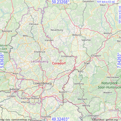
Consdorf GPS coordinates[2]
49° 46' 48.648" North, 6° 20' 22.2" East
| Map corner | latitude | longitude |
|---|---|---|
| Upper-left | 50.23208°, | 5.63638° |
| Center: | 49.78018°, | 6.3395° |
| Lower-right: | 49.32403°, | 7.04263° |
| Map W x H: | 101×101 km | = 62.8×62.8mi |
| max Lat: | 50.13722° ⇑25.4% North |
| Consdorf: | 49.78018° |
| min Lat: | ⇓74.6% South 49.45964° |
| min Long | Consdorf | max Long |
| 5.76583° | 6.3395° | 6.50532° |
| W 86.4%⇐ | ⇒13.6% E |
Elevation
Elevation of Consdorf is 335 m = 1099 ft, and this is 53 m = 174 ft above average elevation for this country.
| Max E: |
502 m = 1647 ft | 14.7% |
| Consdorf | 335 m 1099 ft | |
| Avg. | 282 m = 925 ft | |
Min E: |
143 m = 469 ft | 85.3% |
See also: Luxembourg elevation on elevation.city.
Geographical zone
Consdorf is located in North temperate zone (between Tropic of Cancer and the Arctic Circle). Distance of this North polar circle is 1866.1 km =1159.5 mi to North.| Distance of | km | miles | from Consdorf |
|---|---|---|---|
| North Pole | 4472 | 2778.8 | to North |
| Arctic Circle | 1866.1 | 1159.5 | to North |
| Tropic Cancer | 2929.1 | 1820.1 | to South |
| Equator | 5535 | 3439.3 | to South |


Nearby cities:
15 places around Consdorf: (largest is in red/bold)
• Beaufort
7.1 km =4.4 mi,  330°
330°
• Bech
3.5 km =2.2 mi,  150°
150°
• Berbourg
6.7 km =4.2 mi,  144°
144°
• Berdorf
4.5 km =2.8 mi,  9°
9°
• Biwer
8.6 km =5.3 mi,  164°
164°
• Echternach
6.7 km =4.2 mi,  57°
57°
• Heffingen
7.2 km =4.5 mi,  260°
260°
• Junglinster
10.2 km =6.3 mi,  217°
217°
• Larochette
8.7 km =5.4 mi,  272°
272°
• Manternach
10.6 km =6.6 mi, 144°
• Medernach
9.5 km =5.9 mi,  290°
290°
• Mompach
9.8 km =6.1 mi,  112°
112°
• Steinheim
10.7 km =6.6 mi,  66°
66°
• Waldbillig
4.4 km =2.7 mi, 294°
• Wecker
10.1 km =6.3 mi, 160°
Sources, notices
• [Note1] Compared only with cities in Luxembourg existing in our database
• [Src1] Map data: © OpenStreetMap contributors (CC-BY-SA)
• [Src2] Other city data from geonames.org with taken over terms of usage.
• [Src3] Geographical zone / Annual Mean Temperature by Robert A. Rohde @ Wikipedia
