Sandweiler geodata
Sandweiler (Luxembourg) is a seat of a third-order administrative division; located in Luxembourg in Europe/Luxembourg (GMT+2) time zone. With population of 2,522 people, there are 30 cities with bigger population in this country. Compared to other cities in Luxembourg, 62.7% of cities are located further ↑North; 71.2% of cities are located further ←West and 85.9% of cities have lower elevation than Sandweiler. Note1


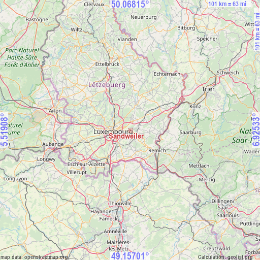
Sandweiler GPS coordinates[2]
49° 36' 52.956" North, 6° 13' 19.956" East
| Map corner | latitude | longitude |
|---|---|---|
| Upper-left | 50.06815°, | 5.51908° |
| Center: | 49.61471°, | 6.22221° |
| Lower-right: | 49.15701°, | 6.92533° |
| Map W x H: | 101.3×101.3 km | = 62.9×62.9mi |
| max Lat: | 50.13722° ⇑62.7% North |
| Sandweiler: | 49.61471° |
| min Lat: | ⇓37.3% South 49.45964° |
| min Long | Sandweiler | max Long |
| 5.76583° | 6.22221° | 6.50532° |
| W 71.2%⇐ | ⇒28.8% E |
Elevation
Elevation of Sandweiler is 336 m = 1102 ft, and this is 54 m = 177 ft above average elevation for this country.
| Max E: |
502 m = 1647 ft | 14.1% |
| Sandweiler | 336 m 1102 ft | |
| Avg. | 282 m = 925 ft | |
Min E: |
143 m = 469 ft | 85.9% |
See also: Luxembourg elevation on elevation.city.
Geographical zone
Sandweiler is located in North temperate zone (between Tropic of Cancer and the Arctic Circle). Distance of this North polar circle is 1884.5 km =1171 mi to North.| Distance of | km | miles | from Sandweiler |
|---|---|---|---|
| North Pole | 4490.4 | 2790.2 | to North |
| Arctic Circle | 1884.5 | 1171 | to North |
| Tropic Cancer | 2910.7 | 1808.6 | to South |
| Equator | 5516.6 | 3427.9 | to South |


Nearby cities:
15 places around Sandweiler: (largest is in red/bold)
• Alzingen
7 km =4.3 mi,  217°
217°
• Contern
3.7 km =2.3 mi,  174°
174°
• Helmsange
7.2 km =4.5 mi,  306°
306°
• Itzig
4.8 km =3 mi,  231°
231°
• Kirchberg
5.3 km =3.3 mi,  281°
281°
• Luxembourg
6.7 km =4.2 mi,  267°
267°
• Moutfort
4.1 km =2.5 mi,  143°
143°
• Münsbach
3.7 km =2.3 mi,  56°
56°
• Niederanven
5 km =3.1 mi,  34°
34°
• Oberanven
5 km =3.1 mi,  17°
17°
• Oetrange
3.4 km =2.1 mi,  126°
126°
• Rameldange
5.1 km =3.2 mi,  8°
8°
• Schrassig
2.7 km =1.7 mi,  100°
100°
• Schuttrange
3.4 km =2.1 mi,  78°
78°
• Uebersyren
4.4 km =2.7 mi, 64°
Sources, notices
• [Note1] Compared only with cities in Luxembourg existing in our database
• [Src1] Map data: © OpenStreetMap contributors (CC-BY-SA)
• [Src2] Other city data from geonames.org with taken over terms of usage.
• [Src3] Geographical zone / Annual Mean Temperature by Robert A. Rohde @ Wikipedia
