Mensdorf geodata
Mensdorf (Grevenmacher) is a populated place; located in Luxembourg in Europe/Luxembourg (GMT+2) time zone. With population of 813 people, there are 97 cities with bigger population in this country. Compared to other cities in Luxembourg, 54.8% of cities are located further ↑North; 84.2% of cities are located further ←West and 71.8% of cities have higher elevation than Mensdorf. Note1


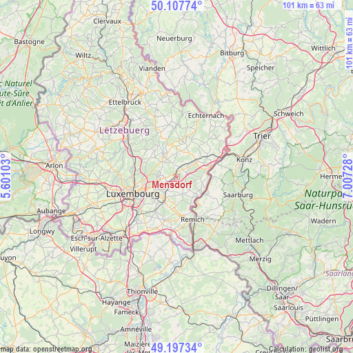
Mensdorf GPS coordinates[2]
49° 39' 16.812" North, 6° 18' 14.976" East
| Map corner | latitude | longitude |
|---|---|---|
| Upper-left | 50.10774°, | 5.60103° |
| Center: | 49.65467°, | 6.30416° |
| Lower-right: | 49.19734°, | 7.00728° |
| Map W x H: | 101.2×101.2 km | = 62.9×62.9mi |
| max Lat: | 50.13722° ⇑54.8% North |
| Mensdorf: | 49.65467° |
| min Lat: | ⇓45.2% South 49.45964° |
| min Long | Mensdorf | max Long |
| 5.76583° | 6.30416° | 6.50532° |
| W 84.2%⇐ | ⇒15.8% E |
Elevation
Elevation of Mensdorf is 248 m = 814 ft, and this is 34 m = 112 ft below average elevation for this country.
| Max E: |
502 m = 1647 ft | 71.8% |
| Avg. | 282 m = 925 ft | |
| Mensdorf | 248 m = 814 ft | |
Min E: |
143 m = 469 ft | 28.2% |
See also: Luxembourg elevation on elevation.city.
Geographical zone
Mensdorf is located in North temperate zone (between Tropic of Cancer and the Arctic Circle). Distance of this North polar circle is 1880.1 km =1168.2 mi to North.| Distance of | km | miles | from Mensdorf |
|---|---|---|---|
| North Pole | 4486 | 2787.5 | to North |
| Arctic Circle | 1880.1 | 1168.2 | to North |
| Tropic Cancer | 2915.2 | 1811.4 | to South |
| Equator | 5521.1 | 3430.7 | to South |


Nearby cities:
15 places around Mensdorf: (largest is in red/bold)
• Betzdorf
4.6 km =2.9 mi,  45°
45°
• Canach
5.5 km =3.4 mi,  163°
163°
• Flaxweiler
3.1 km =1.9 mi,  65°
65°
• Gonderange
6.2 km =3.9 mi,  317°
317°
• Junglinster
6.9 km =4.3 mi,  327°
327°
• Münsbach
3.7 km =2.3 mi,  229°
229°
• Niederanven
3.1 km =1.9 mi,  264°
264°
• Oberanven
4.4 km =2.7 mi,  273°
273°
• Oetrange
7.2 km =4.5 mi,  206°
206°
• Rameldange
5.2 km =3.2 mi,  276°
276°
• Roodt-sur-Syre
1.3 km =0.8 mi,  354°
354°
• Schrassig
5.9 km =3.7 mi, 213°
• Schuttrange
4.6 km =2.9 mi, 214°
• Uebersyren
3.2 km =2 mi,  217°
217°
• Wecker
7.3 km =4.5 mi, 52°
Sources, notices
• [Note1] Compared only with cities in Luxembourg existing in our database
• [Src1] Map data: © OpenStreetMap contributors (CC-BY-SA)
• [Src2] Other city data from geonames.org with taken over terms of usage.
• [Src3] Geographical zone / Annual Mean Temperature by Robert A. Rohde @ Wikipedia
