Peppange geodata
Peppange (Esch-sur-Alzette) is a populated place; located in Luxembourg in Europe/Luxembourg (GMT+2) time zone. With population of 593 people, there are 136 cities with bigger population in this country. Compared to other cities in Luxembourg, 87.6% of cities are located further ↑North; 52.5% of cities are located further ←West and 53.7% of cities have higher elevation than Peppange. Note1


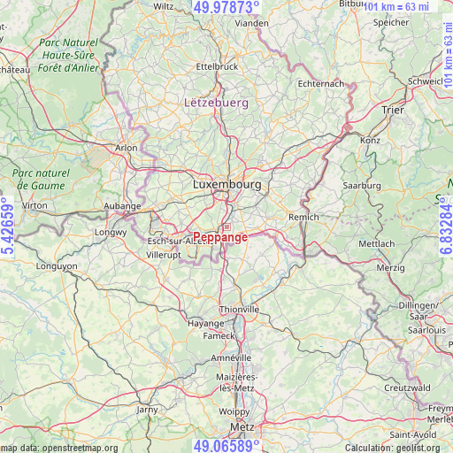
Peppange GPS coordinates[2]
49° 31' 27.984" North, 6° 7' 46.992" East
| Map corner | latitude | longitude |
|---|---|---|
| Upper-left | 49.97873°, | 5.42659° |
| Center: | 49.52444°, | 6.12972° |
| Lower-right: | 49.06589°, | 6.83284° |
| Map W x H: | 101.5×101.5 km | = 63.1×63.1mi |
| max Lat: | 50.13722° ⇑87.6% North |
| Peppange: | 49.52444° |
| min Lat: | ⇓12.4% South 49.45964° |
| min Long | Peppange | max Long |
| 5.76583° | 6.12972° | 6.50532° |
| W 52.5%⇐ | ⇒47.5% E |
Elevation
Elevation of Peppange is 278 m = 912 ft, and this is 4 m = 13 ft below average elevation for this country.
| Max E: |
502 m = 1647 ft | 53.7% |
| Avg. | 282 m = 925 ft | |
| Peppange | 278 m = 912 ft | |
Min E: |
143 m = 469 ft | 46.3% |
See also: Luxembourg elevation on elevation.city.
Geographical zone
Peppange is located in North temperate zone (between Tropic of Cancer and the Arctic Circle). Distance of this North polar circle is 1894.6 km =1177.2 mi to North.| Distance of | km | miles | from Peppange |
|---|---|---|---|
| North Pole | 4500.5 | 2796.5 | to North |
| Arctic Circle | 1894.6 | 1177.2 | to North |
| Tropic Cancer | 2900.7 | 1802.4 | to South |
| Equator | 5506.6 | 3421.6 | to South |


Nearby cities:
15 places around Peppange: (largest is in red/bold)
• Alzingen
5.1 km =3.2 mi,  28°
28°
• Berchem
1.8 km =1.1 mi,  358°
358°
• Bergem
6.3 km =3.9 mi,  270°
270°
• Bettembourg
2 km =1.2 mi,  251°
251°
• Bivange
2.3 km =1.4 mi,  14°
14°
• Crauthem
1.8 km =1.1 mi,  45°
45°
• Dudelange
5.8 km =3.6 mi,  211°
211°
• Fentange
4.6 km =2.9 mi,  22°
22°
• Frisange
4.3 km =2.7 mi,  102°
102°
• Hellange
2.4 km =1.5 mi,  142°
142°
• Hesperange
5.1 km =3.2 mi, 17°
• Huncherange
4.7 km =2.9 mi,  259°
259°
• Noertzange
5.6 km =3.5 mi, 252°
• Roeser
1.9 km =1.2 mi,  40°
40°
• Weiler-la-Tour
5.4 km =3.4 mi,  70°
70°
Sources, notices
• [Note1] Compared only with cities in Luxembourg existing in our database
• [Src1] Map data: © OpenStreetMap contributors (CC-BY-SA)
• [Src2] Other city data from geonames.org with taken over terms of usage.
• [Src3] Geographical zone / Annual Mean Temperature by Robert A. Rohde @ Wikipedia
