Bettembourg geodata
Bettembourg (Esch-sur-Alzette) is a seat of a third-order administrative division; located in Luxembourg in Europe/Luxembourg (GMT+2) time zone. With population of 7,437 people, there are 4 cities with bigger population in this country. Compared to other cities in Luxembourg, 90.4% of cities are located further ↑North; 52.5% of cities are located further →East and 53.7% of cities have higher elevation than Bettembourg. Note1


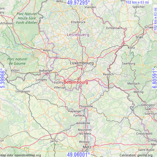
Bettembourg GPS coordinates[2]
49° 31' 6.996" North, 6° 6' 10.008" East
| Map corner | latitude | longitude |
|---|---|---|
| Upper-left | 49.97295°, | 5.39966° |
| Center: | 49.51861°, | 6.10278° |
| Lower-right: | 49.06001°, | 6.80591° |
| Map W x H: | 101.5×101.5 km | = 63.1×63.1mi |
| max Lat: | 50.13722° ⇑90.4% North |
| Bettembourg: | 49.51861° |
| min Lat: | ⇓9.6% South 49.45964° |
| min Long | Bettembourg | max Long |
| 5.76583° | 6.10278° | 6.50532° |
| W 47.5%⇐ | ⇒52.5% E |
Elevation
Elevation of Bettembourg is 278 m = 912 ft, and this is 4 m = 13 ft below average elevation for this country.
| Max E: |
502 m = 1647 ft | 53.7% |
| Avg. | 282 m = 925 ft | |
| Bettembourg | 278 m = 912 ft | |
Min E: |
143 m = 469 ft | 46.3% |
See also: Luxembourg elevation on elevation.city.
Geographical zone
Bettembourg is located in North temperate zone (between Tropic of Cancer and the Arctic Circle). Distance of this North polar circle is 1895.2 km =1177.6 mi to North.| Distance of | km | miles | from Bettembourg |
|---|---|---|---|
| North Pole | 4501.1 | 2796.9 | to North |
| Arctic Circle | 1895.2 | 1177.6 | to North |
| Tropic Cancer | 2900 | 1802 | to South |
| Equator | 5506 | 3421.3 | to South |


Nearby cities:
15 places around Bettembourg: (largest is in red/bold)
• Berchem
3.1 km =1.9 mi,  38°
38°
• Bergem
4.4 km =2.7 mi,  279°
279°
• Bivange
3.8 km =2.4 mi, 41°
• Crauthem
3.7 km =2.3 mi,  59°
59°
• Dudelange
4.4 km =2.7 mi,  194°
194°
• Fentange
6.1 km =3.8 mi, 36°
• Frisange
6.2 km =3.9 mi,  92°
92°
• Hellange
3.6 km =2.2 mi,  109°
109°
• Huncherange
2.7 km =1.7 mi,  266°
266°
• Kayl
5.6 km =3.5 mi,  234°
234°
• Leudelange
6.2 km =3.9 mi,  333°
333°
• Noertzange
3.5 km =2.2 mi,  252°
252°
• Peppange
2 km =1.2 mi,  71°
71°
• Pontpierre
5.7 km =3.5 mi,  290°
290°
• Roeser
3.8 km =2.4 mi, 56°
Sources, notices
• [Note1] Compared only with cities in Luxembourg existing in our database
• [Src1] Map data: © OpenStreetMap contributors (CC-BY-SA)
• [Src2] Other city data from geonames.org with taken over terms of usage.
• [Src3] Geographical zone / Annual Mean Temperature by Robert A. Rohde @ Wikipedia
