Fentange geodata
Fentange (Luxembourg) is a populated place; located in Luxembourg in Europe/Luxembourg (GMT+2) time zone. With population of 1,302 people, there are 64 cities with bigger population in this country. Compared to other cities in Luxembourg, 76.3% of cities are located further ↑North; 62.7% of cities are located further ←West and 63.3% of cities have higher elevation than Fentange. Note1


Fentange GPS coordinates[2]
49° 33' 46.008" North, 6° 9' 14.004" East
| Map corner | latitude | longitude |
|---|---|---|
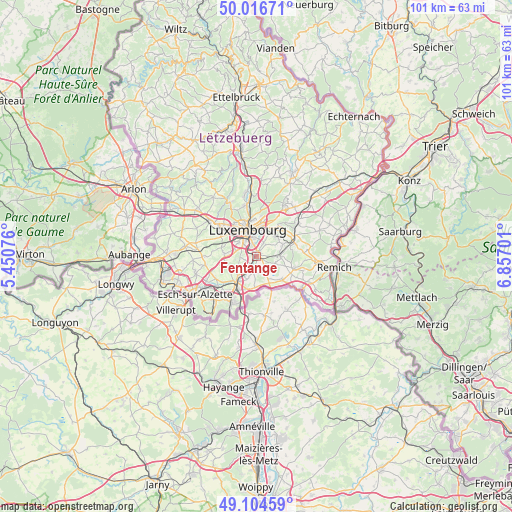
| Upper-left | 50.01671°, | 5.45076° |
| Center: | 49.56278°, | 6.15389° |
| Lower-right: | 49.10459°, | 6.85701° |
| Map W x H: | 101.4×101.4 km | = 63×63mi |
| max Lat: | 50.13722° ⇑76.3% North |
| Fentange: | 49.56278° |
| min Lat: | ⇓23.7% South 49.45964° |
| min Long | Fentange | max Long |
| 5.76583° | 6.15389° | 6.50532° |
| W 62.7%⇐ | ⇒37.3% E |
Elevation
Elevation of Fentange is 263 m = 863 ft, and this is 19 m = 62 ft below average elevation for this country.
| Max E: |
502 m = 1647 ft | 63.3% |
| Avg. | 282 m = 925 ft | |
| Fentange | 263 m = 863 ft | |
Min E: |
143 m = 469 ft | 36.7% |
See also: Luxembourg elevation on elevation.city.
Geographical zone
Fentange is located in North temperate zone (between Tropic of Cancer and the Arctic Circle). Distance of this North polar circle is 1890.3 km =1174.6 mi to North.| Distance of | km | miles | from Fentange |
|---|---|---|---|
| North Pole | 4496.2 | 2793.8 | to North |
| Arctic Circle | 1890.3 | 1174.6 | to North |
| Tropic Cancer | 2904.9 | 1805 | to South |
| Equator | 5510.9 | 3424.3 | to South |


Nearby cities:
15 places around Fentange: (largest is in red/bold)
• Alzingen
0.7 km =0.4 mi,  70°
70°
• Berchem
3.1 km =1.9 mi,  215°
215°
• Bettembourg
6.1 km =3.8 mi, 216°
• Bivange
2.3 km =1.4 mi,  209°
209°
• Contern
5.7 km =3.5 mi, 67°
• Crauthem
3.1 km =1.9 mi,  189°
189°
• Frisange
5.8 km =3.6 mi,  154°
154°
• Hellange
6.1 km =3.8 mi,  182°
182°
• Hesperange
0.6 km =0.4 mi,  342°
342°
• Itzig
3 km =1.9 mi,  23°
23°
• Leudelange
6.4 km =4 mi,  275°
275°
• Luxembourg
5.7 km =3.5 mi, 342°
• Peppange
4.6 km =2.9 mi,  202°
202°
• Roeser
2.9 km =1.8 mi, 190°
• Weiler-la-Tour
4.2 km =2.6 mi,  125°
125°
Sources, notices
• [Note1] Compared only with cities in Luxembourg existing in our database
• [Src1] Map data: © OpenStreetMap contributors (CC-BY-SA)
• [Src2] Other city data from geonames.org with taken over terms of usage.
• [Src3] Geographical zone / Annual Mean Temperature by Robert A. Rohde @ Wikipedia
